The parish of Dunfermline has worked minerals for many centuries and may have the best claim for the earliest recorded working of coal seams in the country. Many of its old collieries are legendary in the history of coal-mining - Urquhart, Pitfirrane, Berrylaw, Pittencrieff, Baldridge, Rosebank, Balmule, Elgin, Wellwood, Venturefair, Townhill, Appin, Muircockhall, Whitefield, Highholm, Muirbeath, Fod, Halbeath - and individual pits of these collieries are well-represented throughout the West Index of the website. No locations for the early pits and mines of the Touch area have yet been identified.
 |
 |
 |
 |
 |
 |
 |
----------------------------------------
|
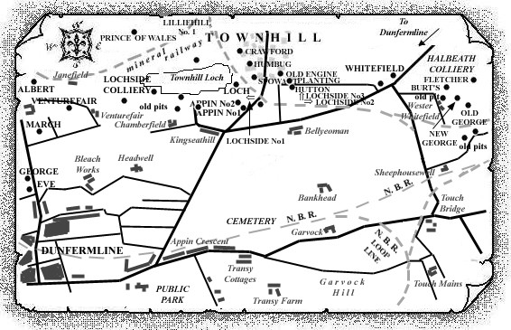
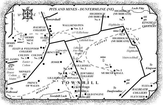
Please note that, in addition to the set of sketch maps, this
entry contains information gathered from early Parish records, the Statistical Accounts of Dunfermline Parish, Fife, and Dunfermline Press reports on incidents and tales of old Dunfermline coalfield and its early pits and mines. |
|---|
----------------------------------------
Old Parish records are a great source of information in spite of the many variations in spellings of names, etc., laid down in these documents. The names of some early miners, and the dates when they were working the early, small coalworks, are revealed in records of births, deaths, and marriages, the first of these records often accompanied by colourful descriptions of what they had been up to, and with whom!
14 Jun 1629, John Spens, collier in Touch, and Jean Brand had Marion; witnesses, George Penman, Alexander Hird, William Walwod, younger.
20 Sep 1640, Patrick Small, collier in Touche, and Elspet Thomson had David; witnesses, David Lainge, William Laing, John Huggoun.
27 Apr 1641, John Hamilton, collier at Touche heuche, and Isobel Nisbet had Elspet; witnesses, Henry Sanders, Alexander Hird, Richard Hamilton.
29 Aug 1641, Gilbert Cumming, collier in Touche, and Janet Tasker had Gilbert; witnesses, James Wedderstoun, Alexander Hird, William Walwood.
19 Dec 1643, James Thomson, collier in Touche, and Bessie Millar had Margaret (in fornication); witnesses, Wm. Mackie in Coklaw, Wm. Cunynghame in Knokes and Andro Thomson.
----------------------------------------
Statistical Accounts of Fife: Parish of Dunfermline - 1791
"... The great abundance of coals in this parish, the
short carriage, and comparatively easy rate at which they can
be purchased, render Dunfermline highly favourable for
carrying on extensive manufactures. Coals may be had at half
a mile's distance.
The inhabitants have the privilege of being served with
coals at a hill belonging to the town at a cheaper rate, than
they are sold to the country at large; at present they may
have 40½ cwt. of coal on the hill for 7d. or laid down
at their doors for 1s. the carriage being 5d. But it is to be
regretted that the road to this coal is bad, and that it is
worked in such a way that carts are often obliged to wait
long on the hill before they are served. ... 184 colliers
were recorded as working in the mines of the parish which
contributed £36,500 to the total value of annual parish
produce calculated to be £147,493..."
" ... Ironstone is found in the lands belonging to Sir Charles Halket, Baronet. Of this mineral there are two seams at a small distance from each other. The uppermost is 4 inches, and the lowermost 2½ inches thick. Being above a seam of coal, they are wrought along with it. They are of excellent quality for making cannon, and have been exported to the Carron Company for that purpose. The ironstone began to be wrought by that Company in 1771, and in 1773 and 1774, there were 60 miners, and as many bearers employed in the mines. Since that period, the ironstone has been wrought by the tacksmen of the coal. - Coal is also found in great abundance in almost every part of this parish. The coal mines of this parish are the most ancient in Scotland. The earliest account of coal used as a fuel, is a charter of William de Oberwill, in which he granted liberty to the Abbot and Convent of Dunfermline to open a coal-pit wherever they inclined, excepting on his arable land, and permitted them to take as much as was necessary for their own use, and to open a new mine whenever the old was exhausted; but not to sell any part of it to others. The charter is dated at Dunfermline, on the Tuesday immediately before the feast of St Ambrose 1291. But at that early period it does not appear that coal was wrought to a great extent. It was only used in the abbey, and by persons of distinction in the country. In progress of time it was worked by crop levels ever since the above mentioned period, there was little exported till about the middle of this century. Even so late as 1763, the annual value of exported coal was only £200; and in 1771, it did not exceed £500 Sterling. The coal-mines, since 1771, have been sources of great wealth to many of the proprietors."
"The next in the same direction is the
colliery of Balmule which comprehends the coal lying under the
lands of Lochhead, Coalton, Lochend, and Balmule. In number of
seams, thickness, depth, and quality, it resembles
Rosebank.
Having mentioned the collieries in the northern
direction, it may be proper to return to those in the middle of the
parish. Of these middle, Baldridge colliery, the property of Robert
Wellwood, Esq., of Garvock, deserves attention. It is in many
respects similar to that of Pittencrieff, and the other mines in
the same direction. The lowest seam is a fine splint coal. This
colliery has been worked for many years, and has been extremely
advantageous to the proprietor. Eastward, in the same line, are the
collieries of Venturefair, Dunfermline town coal, and Whitefield.
They are worked level free, and contain an immense quantity of
excellent coal, which is mostly sold in this country. The town
supplies its inhabitants with this important article at a reduced
price, which makes the fuel cheaper than in any other town in
Scotland.
To the east of these is the colliery of
Halbeath. It contains 8 or 9 seams of good workable coal, amounting
in all to upwards of 30 feet. The lowest or splint seam is the same
as in the other collieries, and is in high repute. Some of the
other seams on the north of a large dike*, which has a S. E.
direction, have been wrought many years ago, by crop
levels.
* Dikes are confused masses of metals, that in some places seem to intersect the earth from the surface to the centre. They are of different thickness. They generally alter the situation of the strata, by cutting them off entirely, and substituting other strata in the place of them, or by elevating or depressing them beyond their natural situation. Sometimes they raise the coal to the very surface, and at other times, sink it to an unapproachable depth. Besides throwing up the coal, they are often of great use in keeping off the water from the neighbouring mines. The dikes with which the coal of this parish is troubled run in different directions, but most generally towards the S. E. and N. W. Their course is however very uncertain. Their elevation is generally from 40 to 80 degrees, and they are composed of every kind of substance, from hard green whin and white spar, to blue clay.
The coal dips nearly in the same manner and
direction as in the west of the parish, but is freer of dikes. This
colliery [Halbeath] was purchased in summer 1785 by Messrs
Campbell, Morison and Company. They have built two large engines.
The one is erected on stone, and the other on a frame of wood. From
this colliery vast quantities of coal are at present exported. The
same seams are found in the lands of Praithouse, and run eastward
to the crossgates into the neighbouring parish.
Sinking pits is not difficult in this parish.
The cover generally consists of a few fathoms of earth, and
afterward freestone and blue metals."
 |
| Eye Sketch |
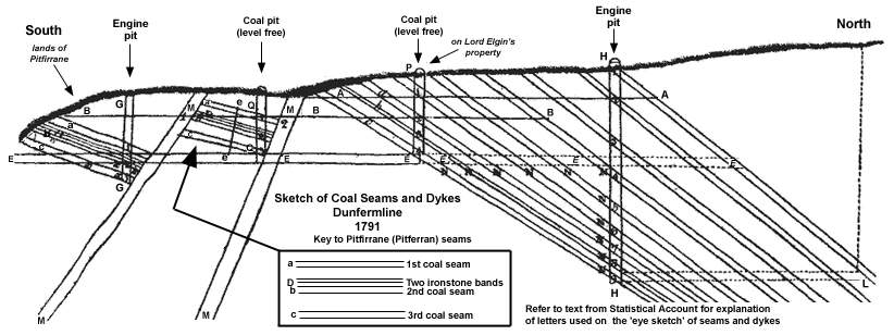
"Explanation of the Eye Sketch. -
Were the seams of coal and dikes in the parish of Dunfermline
visible, they would appear as they are exhibited on the annexed
sketch.
[Some text labels, arrows showing pit
positions and 'key' have been added to the original eye
sketch to make interpretation easier. M. Martin &
Webmasters.]
 |
|
| D. | The two bands of iron-stone, above the two feet or second seam. |
| E. E. E. | The lowest level mine driven from the south of Pitferran, to the face where it is standing in Lord Elgin’s property. |
| E. E. E. | In dotted lines, show how the said level, if continued, would intersect and drain the uppermost seams of coal to the depth of the level. |
| A. A. A. | A cross level, by which the crop of all the north seams have been worked. |
| B. B. B. | A level brought up from the lower grounds, farther south, which is a few fathoms deeper than the one above. |
| M. M. 1 | An upcast dike to the north. |
| a. b. c. d | (between two dikes). The three seams of coal, and two of iron-stone, represented on the south of said dike, which are cast up by it into the north, all above, and drained by the lowest level. |
| Q. Q. | A coal pit, by which the said three seams are wrought and raised level free. |
| e. e. | A kind of dike, or rather stage, which is sometimes met with in the level course of the coal, nearly perpendicular, without casting the coal up or down on either side of it. |
| M. M. 2 | Another large dike, which throws up the seams of coal considerably to the north, and in some parts they dip more rapidly afterward. |
| G. G. | An engine pit on the south side of the first dike, to drain the coals from x. to x. that is below the level. |
| H. H. | Another engine pit to the north of all the dikes, to drain the coal from N. to N. in all the seams below the level. |
| P. E. | A level free pit, on the four lowest seams on the north side of the north dike. |
| 1, 2, 3, 4, 5, 6, 7, 8, 9. | Nine seams of coal on the north side of the second dike, from two to five feet thick each, making in all, upwards of 30 feet of coal under the surface, in some parts of this parish. |
"The three lowest of those nine seams are
supposed to be the three seams a. b. c. on the south. The other six
appear to be upper seams that come on from the north. Those nine
seams are marked where they are intersected by the north engine
pit, and are continued downward, to show, that if there were no
dikes to cast up the coal to the north, it would soon get below the
surface level, and be lost without the assistance of the engine,
which wins from N. to N. in all the seams to the south of
it.
If a level mine were driven from the bottom of
the pit, at H. to L. it would win the upper seams to the north of
it, between the levels E. E. and H. It also shows, that if
it were not for such dikes, the coal would soon run too deep to be
raised to any advantage. Supposing the lowest seam to be 100
fathoms deep at the north engine pit, then the uppermost seam will
be 100 fathoms deep at L, and consequently the lowest seam will be
200 fathoms deep at that point.
The proportion will always be, according to the
dip of the coal, and the elevation of the surface towards the
north.
The level E. E. E. would be about 40
fathoms from the surface at the north engine pit, so that the
engine would have to lift the water about 60 fathoms, and deliver
it into the said level, where it would discharge itself at the
lowest south point.
| Numbers employed. - At the above mentioned coal mines of this parish, there are about, | |
|---|---|
 |
180 colliers. |
| 140 bearers. | |
| 300 persons above ground employed at the works, repairing roads, driving and shipping coals &c. | |
| 400 women and children, who occasionally work, and are supported by the mines. | |
Total, 1020 employed and supported. Besides, there are also 200 horses employed above and below the surface, in performing various operations. There are about 50 waggons constantly employed in carrying coal from the mines to the ships. Having excellent waggon ways, the waggons contain from two to three tons each.
Annual produce and value of Coal.
- The annual quantity of coal raised from the various mines of the
parish amounts to 90,000 tons. Of these, 60,000 tons are exported
from Lime-kilns, Brucehaven, and Inverkeithing. The remaining
30,000 tons are consumed in the town and parish of Dunfermline, and
the immediate neighbourhood.
The great coal is sold at from 6s. to 7s. the
ton; the chews from 5s. to 6s.; and the small at 3s. the ton;
valuing the whole at 5s. the ton, the total annual value of coal
amounts to £22,650 Sterling. Of this sum, there are £3000
annually expended on timber, iron, ropes, incidents, &c.
&c. and £13,000 for labour.
Price of Labour and Provisions. - The miners in the horse-pits, without bearers, make about from 1s. 6d. to 2s. 6d. a-day; with bearers, from 2s. 6d. to 3s. 6d.; and the people above ground, from 1s. 4d. to 1s. 6d. a day. ..."
---------------------------------------
Statistical Accounts of Fife : Parish of Dunfermline - 1845
" ... Mineralogy, Geology, Soil. -
The fields of coal in this district are very extensive, and appear
to have been among the most ancient in Scotland. I am aware of only
two notices of coal, one in England, the other in Scotland, prior
to that in Dunfermline, the former being variously dated, 1234,
1239, and 1245: the latter 1284-5.
In 1291, William de Oberwill, proprietor of
Pittencrieff estate, adjoining to the town, granted a charter to
the abbot and convent of Dunfermline, bestowing on them the
privilege of working one coal-pit, wherever they chose, on any part
of his property, except the land which was arable: and when one was
exhausted, of opening another at their pleasure, as often as they
considered it expedient, but for their own exclusive use, and with
an express prohibition to sell coals to others. He also, in the
same charter, gave them a right to quarry and hew as many stones as
they pleased, on the same conditions, with the liberty of making
"free use of all the roads and footpaths through his lands
of Petyncreff and of Galurigs, which they at any time had employed,
or been in the practice of employing." To this charter
were affixed not only his own seal, but, at his instance, those of
the Lord Bishop of St Andrews, and of Robert de Malevilla
(Melville), and it is dated at Dunfermline on the Tuesday
Immediately before the feast of St Ambrose, bishop and confessor,
1291.
Accordingly, traces of these operations still exist in the coal works or old excavations which have been found in the Pittencrieff quarry; from which it is likely that some of the pits alluded to were in the vicinity of it to the north. Deep shafts would not be necessary, as the coal has been seen to crop out in different places to the west and east of this. The pits, too, of the East Baldridge Colliery, the property of Mr Wellwood of Garvock, were in the same neighbourhood, a little farther north, and wrought at no distant period. And it is well known to many, that, anciently, the coals from the colliery were conveyed in carts along a road passing through the Pittencrieff parks by the west side of the mansion-house, the vestiges of which still remain, and part of Gallowridge grounds to the two harbours at the village of Limekilns, and chiefly to that named Brucehaven, a practice which may have had its origin in the grant above noticed.
But at the early period of 1291, there was
little coal wrought in the parish. It was then a luxury enjoyed
chiefly by the inmates of the Abbey, and persons of distinction in
the country. Arnot in his history of Edinburgh, p. 85, records two instances
illustrative of coal being a rare, though useful commodity, so late as the fifteenth
and sixteenth centuries.
"Aeneas Sylvius," says he, "who afterwards assumed the purple
under the name of Pius the Second, visited this island about the middle of
the fifteenth century. He relates that he saw in Scotland 'the poor
people, who in rags begged at the churches, receive for alms pieces of stone,
with which they went away contented. This species of stone,
(says he) whether with sulphur, or whatever inflammable substance it
may be impregnated, they burn in place of wood, of which their country is destitute.
And Boethius in his description of Scotland, his native country, written in the beginning
of the sixteenth century, says, "There are black stones also digged out of the
ground, which are very good for firing, and such is their intolerable heat, that they
resolve and melt iron, and therefore, are very profitable for smiths and such artificers
as deal with other metals; neither are they found any where else (that I know of) but
between the Tay and Tyne, within the whole island."
Coal was only partially used in London even so late as 1640, and it caused, it is said, the
fashionable inhabitants of the Court party of the town, to pass many a jeer at the city
people on account of their adopting it.
In progress of time coal came to be generally
used a fuel in Dunfermline, as in other places: and when trade was
prosperous, even to be exported to foreign parts. Although it
continued to be wrought by crop-levels long after 1291, there was
little exportation till the middle of last century. Even so late as
1763, the writer of the last Statistical Account of the parish,
states that the annual value of exported coal was only £200,
and in 1771, that it did not exceed £500 Sterling. The
coal-mines became after 1771, and have continued to be, very
lucrative to many of the proprietors.
From a remote period," the
same writer records, "the family of Pitferrane obtained
from Government the privilege of exporting these coals to foreign
parts, free of all duty whatever. The original privilege was
renewed by Queen Anne, on December 21, 1706, and ratified in
Parliament on March 21, 1707. The family continued to enjoy the
privilege till 1788, when it was purchased by Government for
£40,000 Sterling, when the property that could injure the
revenue was nearly exhausted."
Although the coal in the parish has thus been
dug for upwards of five centuries, it is still most abundant.
Nearly 3000 acres are calculated as still to work, a portion of
that quantity having been ascertained by general boring, and the
rest conjectured on good grounds to be of the coal-formation, with
such interruptions, more or less slight, as commonly occur in
coal-fields.
The coal-strata extend from Culalo Hills on the
east to the Saline Hills on the west, and pervade in that line of
bearing the whole of the parish of Dunfermline. In some parts there
have been discovered 10 or 12 seams to the dip, the aggregate
thickness of which amounts to upwards of 40 feet, contained in beds
varying from a few inches to seven or eight feet in thickness.
These are different in quality as well as in thickness, but in
general improve towards the west. By being divested of part of
their bitumen, they partake of more heat and durability, and, from
a hard splint, they become a rich caking cubical coal, until they
approach the trap hills, when they lose their bituminous quality
altogether, and are changed into a blind anthracite, or
glance-coal.*
* This coal is termed by the workmen in Fife, Rotten ratchell, or Foul rahill, and is used in furnaces of steam-engines and breweries.
Mr Geddes, mining engineer, a native of this parish, and well-acquainted with its coal-fields, in a description which he gave to Leonard Horner, Esq. of the locality at Hallbeath, where a tooth of the Megalichthys had been discovered, which will afterwards be taken notice of, makes some valuable observations on the Dunfermline coal-field.
The dykes, faults, troubles, slips, and hitches, as they are locally called, but
more properly fissures, fractures, or rents, are very frequent in the district, and are
generally composed of mixtures of other and various materials, as hard green trap,
white spar, blue clay, and all the substances found in the superincumbent strata.
Although, too, they are inconvenient to the miner, they are known to be of great
benefit in colliery operations, by rendering the coal more accessible in consequence
of heaving it up, and by preventing floodings, and spread of accidental fire, by
means of the alternations which they occasion.
Their run or line of bearing in
this district, as seen in the accompanying map (Plate I), is generally from south-east
to north-west, and they vary in width from a few inches to 150 and even 240 feet.
They throw up or elevate the position of the strata to the north or north-east in some
cases, not more than one inch, and, in others, upwards of 20 or even 45 or 50 fathoms,
and thus bring the coal and other minerals within a moderate depth, which would
otherwise be unapproachable on account of the land ascending nearly in the same
line with the more regular dip of the strata.
And it is worthy of remark, as the evident indication of a wise and kind Providence,
that the greatest upheaving of these is at Hallbeath, and the northern division of the
Elgin colliery where the surface rises the highest.
The dykes and slips, seen near the surface, have, like those in the Mid-Lothian coal-field, not been found to stop or disappear in their descent from it, to the depth to which the coal operations have extended; while a small fault, noticed in the section of the Hallbeath colliery (Plate II), near the bottom of the engine-pit, was not ascertained to rise higher than is there marked. These dykes and slips have also been observed in this quarter in most cases to widen as they go down. Longitudinally, they frequently cease or terminate.
Many of the hitches, which appear in the splint coal, are not seen in the upper seams, and vice versa. The dykes and slips, as may be seen by inspecting the map, (Plate I) bear upon the trap hill, or hills in their vicinity, as on the hill of Beath (and Cullalo Hill in the parish of Aberdour, not shewn), south-east, and Craigluscar and Saline hills north-west, which are the boundaries of the coal-field in the western district of Fife, and in all probability, the trappean masses greatly contributed to upraise and derange the strata, which these dykes and slips intersect.
The coal near the dykes, even the sandstone ones, is generally, though not always, deteriorated,
being sometimes of so soft and sooty a nature, as to be unfit for any purpose whatever.
The particular dykes in the district will be specified under the head of each colliery.
The coal-strata in the district dip in various directions, but chiefly towards the north, north-west,
and north-east, except where they appear to lie to themselves in the same plane, in which case
they dip more frequently towards the north-east.
But, as the coal-field in general assumes
the form, in some places, of a circular, and in others, of a long elliptical basin-shaped hollow,
or rather of segments of these figures, the line of dip changes its direction, as the line of bearing
diverges from a straight to a semicircular line. As these basins, however, have never been
found entire or completely formed, the north segment being always cut off by a dyke, slip, or
such other dislocation, the coal and concomitant strata have never been found to dip to the
south, although they incline in almost every direction.
In the Wellwood colliery, the direction
of the dip is for the most part towards the north, until the strata reach the dislocation in the
centre of the basin, where, instead of dipping, they take a gentle rise, and continue to do
so, as far as has yet been ascertained by the mining operations.
From the southern boundary of the Townhill field to the Lochhead or great dyke, the strata dip, in a north-easterly direction, about 18°; and continue so for a short distance on the north side of it, after which they dip nearly due east, at an angle of 16°, as per accompanying section of that colliery. (Plate II.)
At Hallbeath the strata dip towards the north, north-west, and north-east. The declivity of the seams is from 1 foot of fall for every 6 in length, or from 1 foot in 8; but in many cases, where near a dyke or other trouble, it is found to be from 1 foot in 2 to 1 foot in 3.
Access to the coal in this district is at present obtained only by sinking pits. The most approved form of these is circular, from 6 to 9 feet in diameter; but some are of an oblong, and others of an elliptical shape, according to the taste or convenience of the mine master. Their depth, of course, depends on that of the seam which is to be wrought. Where they do not exceed twenty fathoms in depth, the coal is brought to the surface by a gin, or machine wrought by horses; but when exceeding that depth the steam-engine is usually applied, as being both more expeditious and economical.
The method of working the coal varies according to the thickness of the seams, the depth
under the surface, and the nature of the roof and pavement, or of the strata immediately above
and beneath the coal. The old and most common method is called the "Post and Stall" or
"Stoop and Room" according to which, in some cases, two-thirds of the coal are
wrought, and one-third is left in pillars for the support of the superincumbent strata; in others,
where the roof is considered strong, three-fourths, and in some even four-fifths, are taken out.
This method is practised at the Townhill, Hallbeath, and Cuttlehill collieries; but the new and
most approved mode is that which is named "the Long Wall, or Shropshire Method,"
which consists in working out and bringing to the surface the whole coal-seam; and instead
of leaving pillars for supporting the roof, with intermediate spaces, the roof is in the first instance
artificially kept up by fir stabs, and afterwards made to rest upon buildings formed of dry stones,
mid-stones, and other rubbish obtained from the superincumbent or lower strata, and when
necessary by part of the coal itself, all heaped up closely behind the workers.
The advantages of this method are, that the whole, or nearly the whole, quantity of coals is taken
out, and there is greater security to the workers against the danger arising from fire-damp or
choke-damp; for there are no vacant spaces allowed to remain where the impure gas may
accumulate, as in those between the pillars, according to the Post and Stall plan, and
whatever there may be of this gas is dispelled by a current of good air circulating from the pit
bottom, where a fire is kept burning, or by communication with another pit, along the wall faces
before the workers.
On this plan, too, 10 cwt. more of coals can be put out by each collier.
This is the method practised at the Elgin, and within these four or five years past at the Wellwood
collieries. The adoption of it, however, is said to depend upon the coal and concomitant strata
admitting of it; for if the seam be five feet and upwards, there is no occasion to take down any
of the roof to make roads for conveying away the coal, and hence there is not rubbish sufficient
to fill up the large vacancies caused by the excavations.
The Longwall method is reckoned most advantageous to the proprietor, as there is by it less
coal left unworked, without being paid for. The coals are brought from the wall faces in corves*
or tubs by females, who push or drag them on trams to the pit bottom, or to the horses that
draw them to the bottom of the shaft, from which they are raised by steam-machinery to the surface.
* [There are now used, at the Wallsend pit, cages similar to those at present in practice on the Tyne and Wear, which consist of an iron-frame, containing one, two, or even three tubs, made of iron or wood, and which slide by means of grooves, on rods fixed to the sides of the pit, whereby the tear and wear of the corves, from the oscillating motion in ascending and descending, is prevented, greater security to the workman is attained, and a larger quantity of work is performed in nearly the same time.]
From the nature of their employment these females are named Putters. When the coal was wrought near the crop, or at a moderate depth, the women used to bear the coal on their backs, by a stair in the pit to the surface, on which account they were called Bearers. There are none who do so now in this parish, but very lately a few were thus employed at the Townhill colliery, when it was in the hands of the burgh. It certainly were most desirable, that the practice of employing females in underground operations, now so generally reprobated, were, for the sake of morality, and even common humanity, here, as it is in many other places, entirely exploded.**
** [Since these words were penned, an Act has passed the Legislature, August 1842, prohibiting the employment of females in mines and collieries after the first day of March 1843.]
Still it is right to say, as personally known to the writer, that not a few very respectable, and some decidedly pious, females are at present engaged in this occupation, and are no doubt so, as a necessary or convenient means of livelihood. What is almost equally objectionable is the employment in this and other kind of work of very young boys and girls, often before their education is completed, and mainly for the purpose of adding a little pittance to the income of their parents. This practice, however, from the payments for education being now generally made universal and compulsory, as shewn under the head "Education," is not so prevalent as it once was.
The colliers are paid by the ton or cwt., and are generally allowed to put out as many coals as they please. But their own union law restricts each man to a limited quantity, and he cannot exceed his neighbour, so that good and bad workmen are put on an equality, as to amount of earnings. The average quantity which each man engages to raise per day, may be stated at from 32 to 46 cwt., according to the thickness of the seam and difficulty in working it. Their average wages at present are from 2/9 to 3/3 per day, after deducting expenses for light and other things, with free house and garden, and fire-coals for the hewing.
A boy at ten years of age is reckoned a quarter man, and allowed by a regulation among themselves to
put out the fourth part of the quantity that is raised by a full man, in which case, however, the father or brother
generally works the coal, since the boy is only capable of assisting in filling it into the corves. A boy is
reckoned at twelve or fourteen years of age half a man, at fifteen or sixteen a three-quarters man, and at
eighteen a full man; and they put out their respective quantities of coal accordingly.
The women, or putters, are paid in a similar proportion, according to their ages, and receive from 8d. to 16d. per
day. Girls, under ten years of age, are paid 6d. per day, for keeping doors, &c. to direct the ventilation
of the workings, named trappers, as opening and shutting trap-doors. For six years previous to the present
period, all the under-ground workers received higher wages than those above noted. The wages are paid
once a fortnight.
The collieries in this district are generally free from any dangerous amount of inflammable air, or "carburetted hydrogen gas," commonly named by the miners, "fire-damp," as often occasioning, when very abundant, awful explosions of fire. It occurs, however, occasionally in close workings, or in perforating some of the dykes, or near them, from which Mr Milne well reasons in his late excellent Memoir on the East and Mid Lothian Coal-fields, that it would appear that it does not exist solely in the cells of coals, but proceeds also from the metals contained in the fissures of the dykes. At the Wellwood colliery, the safety lamp has at times, but not frequently, for this reason to be used.
"Carbonic acid gas," or "choke-damp", so named as choking or suffocating the miner, or after-damp, as sometimes following an explosion of fire-damp, in a greater or less extent pervades the whole coal-workings; but it is seldom fatal, being easily discovered by approaching it with a candle or lamp, the flame of which it suddenly extinguishes, which gives the miner warning to retrace his steps, until a supply of fresh air is brought to displace it.
I shall now give some details as to the particular collieries in the district.
Elgin Colliery. - The largest
proprietor is the Earl of Elgin, who possesses a coal-field, the
whole area of which, wrought and unwrought, may be stated at from
2600 to 2700 acres.
About 800 or 900 of these which are the most southern, and on the lands of Pitferrane,
Urquhart, and Pittencrieff, are nearly exhausted, the remainder about 1800, one-half of which are in the barony of
Balmule, and the other in the lands of Luscar, in the adjoining parish of Carnock, and on those of Clune, partly in
that, but chiefly in Dunfermline parish, including Swallowdrum, Rosebank, and West Baldridge, are yet to work.
A large portion of this extensive coal-field Lord Elgin holds in lease of 999 years, from the Pitferrane family, about 150
acres on a short lease, which expired at Martinmas 1839, from James Hunt, Esq. of Pittencrieff, and the remainder
is his Lordship's own property by purchase.
The coal-seams are of various quality, and some
of them, especially the deepest, are extremely valuable. Almost all
the coal partakes more or less of the caking quality and soft
texture of the Newcastle coal. It is easily ignited, possesses
great heat and durability, and produces very few ashes of a brown
colour, which renders it cleanly and economical for all
purposes.
A new pit was completed at the end of the year
1839, 105 fathoms deep, named the "Wallsend Pit" *, which
has entirely superseded the use of the Baldridge pit in the
vicinity.
* The common name Wallsend means the end of the wall of Severus, on the northern bank of the Tyne, a few miles below Newcastle, where the coal is got.
It is the deepest coal shaft in Scotland, and
probably one of the most valuable. It is very productive, yielding
at present as much coal as all the other pits together previously
did at any one time.
Subjoined is a section of the different strata
in this pit, showing the order of their superposition and
succession, as well as the thickness of each. As the shaft is sunk
in the bottom of an elliptical basin, the general dip of the strata
is towards the shaft, as to a common centre from all directions,
except the north, where the segment of the basin is cut off by a
dike. The general angle of the dip will be from 16o to
20o.
Section of the strata in the Wallsend Pit in West Baldridge, the property of the Earl of Elgin.
| Coal. Fath. Ft. In. |
Various Strata. Fath. Ft. In. |
||
| 1. Soil and clay mixed with sand, | 2 4 0 | ||
| 2. Soft brown sandstone, | 4 3 0 | ||
| 3. Coal soft and foul, | 0 3 0 | 0 3 0 | |
| 4. Soft brown sandstone, | 1 2 0 | ||
| 5. Hard white sandstone, | 1 3 0 | ||
| 6. Slate clay or blaes mixed with sand, | 0 1 6 | ||
| 7. Coal, | 0 2 0 | ||
| 8. Bituminous stone or slate, | 0 0 5 | ||
| 9. Coal, | 0 1 7 | ||
| ----- | 0 4 0 | ||
| 10. Slate-clay or blaes, | 0 1 3 | ||
| 11. Soft white sandstone, | 0 3 0 | ||
| 12. Slate-clay or blaes, | 0 0 9 | ||
| 13. Sandstone plies mixed with blaes, | 1 2 9 | ||
| 14. Slate-clay or blaes, | 0 2 4 | ||
| 15. Coal, | 0 3 6 | ||
| 16. Bituminous stone, | 0 0 5 | ||
| 17. Coal, | 0 2 9 | ||
| ------ | 0 6 8 | ||
| 18. Slate-clay or blaes, | 0 1 10 | ||
| 19. Sandstone, | 0 2 1 | ||
| 20. Sandstone plies and blaes alternately, | 0 3 0 | ||
| 21. Sandstone, | 0 3 0 | ||
| 22. Slate-clay or blaes, | 0 4 4 | ||
| 23. Coal, | 0 0 7 | 0 0 7 | |
| 24. Slate-clay, | 0 1 2 | ||
| 25. Sandstone, | 0 3 7 | ||
| 26. Slate-clay, | 1 3 3 | ||
| 27. Slate-clay mixed with sandstone, | 0 1 2 | ||
| 28. Slate-clay, | 0 3 0 | ||
| 29. Sandstone, | 0 0 5 | ||
| 30. Slate-clay, | 0 1 0 | ||
| 31. Sandstone, | 8 1 6 | ||
| 32. Slate-clay, | 1 4 8 | ||
| 33. Coal, | 0 0 5 | 0 0 5 | |
| 34. Slate-clay, | 0 3 2 | ||
| 35. Coal, | 0 2 6 | ||
| 36. Bituminous stone, | 0 0 3 | ||
| 37. Coal, | 0 3 0 | ||
| ------ | 0 0 9 | ||
| 38. Sandstone plies and blaes alternately, | 1 2 8 | ||
| 39. Slate-clay, | 0 2 5 | ||
| 40. Coal, | 0 2 9 | ||
| 41. Sandstone mixed with blaes, | 0 1 10 | ||
| 42. Coal, | 0 2 7 | ||
| ------ | 1 1 2 | ||
| 43. Sandstone with a ply of slate-clay, | 2 2 8 | ||
| 44. Slate-clay, | 0 2 5 | ||
| 45. Coal, | 0 5 2 | 0 5 2 | |
| 46. Slate-clay, | 0 4 0 | ||
| 47. Sandstone, | 0 0 8 | ||
| 48. Slate-clay, | 0 3 10 | ||
| 49. Coal, | 0 2 5 | 0 2 5 | |
| ----- | |||
| Depth of Pitferrane level | 41 0 3 | ||
| 50. Slate-clay, | 0 2 4 | ||
| 51. Coal, | 0 2 3 | 0 2 3 | |
| 52. Slate-clay with balls of ironstone, | 0 3 0 | ||
| 53. Fire-clay, | 0 0 3 | ||
| 54. Slate-clay with balls of ironstone, | 0 2 5 | ||
| 55. Coal, | 0 1 11 | ||
| 56. Bituminous stone, | 0 0 4 | ||
| 57. Coal, | 0 1 4 | ||
| ----- | 0 3 7 | ||
| 58. Slate-clay, | 0 4 5 | ||
| 59. Ditto mixed with sandstone, | 0 4 2 | ||
| 60. Sandstone, | 2 0 3 | ||
| 61. Coal, | 0 3 9 | 0 3 9 | |
| 62. Sandstone, | 2 0 11 | ||
| 63. Ditto mixed with blaes, | 0 3 6 | ||
| 64. Slate-clay, | 1 3 9 | ||
| 65. Sandstone mixed with blaes, | 0 2 10 | ||
| 66. Sandstone, | 0 2 8 | ||
| 67. Sandstone mixed with blaes, | 0 3 0 | ||
| 68. Sandstone, | 1 4 1 | ||
| 69. Slate-clay, | 2 4 4 | ||
| 70. Sandstone, hard, | 0 1 4 | ||
| 71. Slate-clay, | 0 2 5 | ||
| 72. Coal, | 0 0 7 | 0 0 7 | |
| 73. Slate-clay, | 1 4 3 | ||
| 74. Sandstone, | 0 6 9 | ||
| 75. Coal, | 0 1 6 | 0 1 6 | |
| 76. Slate-clay, | 0 2 3 | ||
| 77. Ditto mixed with sandstone, | 0 2 3 | ||
| ------ | |||
| 78. Slate-clay, | 0 3 1 | ||
| 79. Coal, | 0 0 7 | 0 0 7 | |
| 80. Sandstone mixed with blaes, | 3 2 5 | ||
| 81. Coal, | 0 1 2 | 0 1 2 | |
| 82. Slate-clay, | 0 1 8 | ||
| 83. Sandstone mixed with blaes, | 0 4 6 | ||
| 84. Sandstone, | 2 1 8 | ||
| 85. Slate-clay, | 0 2 0 | ||
| 86. Ditto mixed with sandstone | 2 5 0 | ||
| 87. Sandstone, | 1 3 0 | ||
| 88. Ditto mixed with blaes, | 0 1 8 | ||
| 89. Slate-clay or blaes, | 0 4 9 | ||
| 90. Coal, | 0 1 7 | 0 1 7 | |
| 91. Sandstone with petrifactions | 2 3 7 | ||
| 92. Slate-clay, | 1 5 5 | ||
| 93. Coal, | 0 0 2 | 0 0 2 | |
| 94. Slate-clay (light grey), | 0 5 0 | ||
| 95. Ditto mixed with sandstone, | 0 5 3 | ||
| 96. Sandstone, | 9 0 6 | ||
| 97. Slate-clay, | 0 3 5 | ||
| 98. Coal, | 0 2 8 | ||
| 99. Bituminous stone, | 0 0 3 | ||
| 100. Coal, | 0 0 10 | ||
| ------ | 0 3 9 | ||
| 101. Slate-clay, | 0 3 0 | ||
| 102. Ditto marked with sandstone, | 0 1 6 | ||
| 103. Slate-clay, | 0 1 6 | ||
| 104. Sandstone mixed with blaes, | 1 2 7 | ||
| 105. Sandstone, | 3 3 0 | ||
| 106. Slate-clay, | 0 1 7 | ||
| 107. Coal, | 0 2 0 | 0 2 0 | |
| 108. Sandstone plies mixed with blaes, | 3 1 0 | ||
| 109. Slate-clay or blaes, | 1 0 0 | ||
| 110. Coal, | 0 3 8 | 0 3 8 | |
| 111. Sandstone, | 1 4 0 | ||
| ------ | |||
| 105 1 0 |
"In the preceding section," the manager remarks,
"there are 27 beds of coal of various thicknesses amounting to
56 feet 3 inches. Several of these are so thin that they cannot be
wrought to advantage. But there are 19 of them containing 49 feet 8
inches of coal when taken in sections, as stated in the left hand
column, which can be wrought in 13 divisions or separate workings.
Each of these divisions is generally denominated one seam, without
any regard to the midstone which lies between the different beds or
leaves.
The whole of these seams partake less or more of the
caking quality and soft texture of the Newcastle coal, and, in
particular, the three undermost are of the very richest
kind."
The coal in this field was long wrought by crop or day-levels, that is, by levels without engines, in contradistinction to engine-levels, and so named because the water issues to day, or open air naturally, although the level is driven by artificial means. An engine-level is that from which the water is pumped to the day-level or to the surface. The day-levels are marked in the map by dark blue lines, and are as follows:-
1st, The Rosebank level, which averages from 1 to 18 fathoms deep, and
issues at Blackburn.
2d, The Urquhart level, about 43 fathoms deep, and issues at the south of
Urquhart farm-steading.
3d, Pitferrane level, 50 fathoms deep, but only 41 fathoms as noted in the
preceding section of the strata in the Wallsend Pit, which is sunk in low
ground. It issues at Malcolm's Wheel, in the Lynne Burn, near Pitliver
House.
All these are in the same direction, which is generally north, or rather north-east.
Since the coal, above these day-levels, has been exhausted, it has been
necessary to sink farther to the dip of the strata, and raise the water by steam
into the day-levels, which saves a great proportion of engine power by not
lifting the water to the surface.
The field is intersected, as already noticed, by various dykes, laid down in the map,
and coloured red.
1st, The first and most southern is the White Myre dyke, consisting of a
conglomeration of the different strata, superincumbent upon the coal, without
any trap. It runs nearly east and west from about Wooers Alley Cottage,
in the town of Dunfermline, through Golf Drum, then on the north side of Colton
farm-steading, and of the James and Level Pits, and breaks itself on the north side
of Berry lawtop, upon a cross trap-dyke, or nip, as it is called, running nearly south and
north. On its meeting this trap-dyke, it diverges into several ramifications, as exhibited
in the map, towards the west, north-west, and south-west, and these being of less
magnitude than the previous main dyke, the coal has been all taken out between
them, to the crop, or outburst of the seams, which is towards the west in that quarter.
The White Myre dyke throws up the strata to the north about 25 fathoms.
2d, The Tod-firs or Coney-hole dyke runs south-east and north-west from near Wester
Baldridge House, and north of the New Wallsend Pit, through Tod-firs to the north
side of the Bruce Pit in Clune, towards Luscar Den, and elevates the strata to the north
about 15 fathoms.
3d, The Rosebank dyke runs nearly north-east and south-west from the north of
Leadside farm, through the north side of the north field of Baldridge farm, through
Rosebank plantations, Rosebank feus, and joins the Tod-fir dyke near the Bruce
Pit. It throws up the coal to the surface fully 50 fathoms.
4th, The Lochhead or great dyke runs from the Hallbeath Colliery, north of the Townhill
houses, near Colton house, onward to Lochhead farm-house, and is supposed to lose
itself in the Craigluscar Hills. It raises the coal to the north, or north-east, at Hallbeath,
about 40 fathoms. The dip and rise of the metals vary on the east from what they are
on the west side of it, rising up to it on both sides, and of course dipping upon the
east towards the east, and upon the west towards the west, but the dyke has not
been much proved.
There is very little trap in the Elgin coalfield, but it abounds in the adjoining
Craigluscar Hills on the west and north-west, which has had the effect of expelling
the bituminous quality from the coal in its immediate neighbourhood, and converting
it into blind coal or anthracite. As the strata recede from these trap-hills towards the
east, the coal becomes of a caking quality, and still farther to the east a hard free-burning
splint.
The trap-dyke above alluded to which runs north and south, and meets the
White Myre dyke running east and west, intersects the contiguous sedimentary strata,
without varying the position on either side.
The varieties of Lord Elgin's coal, their prices at the pit-mouth, and the uses
to which each is generally applied, are as follows:-
Splint coal, great and chews, sold at 8/4 per ton.
Small coal sold at 4s 6d. per ton.
The chews are not separated from the great coal, but are sold mixed.
Splint, which is the finest, and produces fewest ashes, is applied to best family use and
steam navigation.
The whole quantity of coals raised at the Elgin Collieries, on an average of the last five years and upwards, has been fully 60,000 tons, 40,000 of which have been exported, chiefly to the ports on the Baltic and Mediterranean Seas, the remainder being disposed of by land sale, and consumed at the Charleston Limeworks. The whole of this quantity is now produced at the Wallsend pit alone.
At the Wallsend Pit there are three steam-engines, 1st, A pumping engine for draining
the coal, about 100-horse power, at 24 lb. pressure per inch on the piston.
2d, A winding-engine for drawing up the coal, about 40-horse power, at the same pressure
as above.
3d, A winding-engine, about 30-horse power, and same pressure.
All these are high-pressure engines, and their power can be increased.
At the Baldridge Pit, there is a high-pressure winding engine on the surface,
of 16-horse power, at 24 lb. pressure on the piston, which can be increased at
pleasure, used for cleaning the main level, and working ironstone and fire-clay
occasionally.
The number of people at present employed at this colliery is about 620, of whom
450 are males, including men and boys, and 170 females, women and girls. Of the
males, 250 are coal-hewers, redsmen, &c, who work underground, and the
remaining 200 are smiths, wrights, masons, sawers, carvers, engine and gig men,
pithead-men, waggon-fillers, waggon-drivers, labourers, shippers, &c. The
170 females are putters, trappers, &c, who work underground, including two
or three women who work on the pithead. The total number of souls dependent
on the colliery for daily support is about 1500, of whom 760 are males, and 740
are females.
This colliery supplies coal for making coke at Charleston, where there are twelve
kilns or ovens. The quantity of coal, converted into coke, is about six tons per
day, producing somewhat more than two tons of coke.
His Lordship's coal is conveyed to his limeworks and shipping at Charleston
by a railroad, the two inclined planes of which, near the town of Dunfermline,
are much admired, and were executed, on a change of the line of the rail-road in
1821, at a very great expense, under the direction of the late ingenious Mr Landale
of Dundee.
The Wellwood coal for exportation is now also conveyed along this railway, which
is connected with that colliery by a branch line. His Lordship upholds the railway
and waggons, and supplies all the horses, from twenty to twenty-four in number,
including those required by himself, and Mr Spowart pays about 2s. 2d. per ton
for carriage.
The railway is about six miles in length, but longer when the branches to the different
pits, &c, are taken into account. There are from 100 to 500 tons of coal generally
carried along it in a day, according to the demand, or the number of vessels lying
in the Charleston harbour waiting for them.
The late Earl of Elgin recently erected offices, workshops, and dwelling-houses for his coal-hewers, and other work-people, in the vicinity of the New Wallsend Pit, on a very extensive scale, at great expense, and in a style, too, very creditable to his Lordship's well known taste. The public and benevolent spirit of this nobleman was worthy of all praise, as it was highly and deservedly appreciated by the numerous people under his employ.
Wellwood Colliery. - Immediately
to the east of the Elgin is the Wellwood Colliery, belonging to
Andrew Wellwood of Garvock, Esq. It is situated about a mile north
of Dunfermline, and is leased by James Spowart of Venturefair and
Bellfield, Esq., a very enterprising and successful coalmaster. The
colliery was a few years since greatly increased in value, both to
the proprietor and lessee, by the erection of a powerful
steam-engine for drawing the water, whereby an excellent seam of
splint-coal was reached, much admired for its clearness and purity.
The coal from this work is extensively used in the town of
Dunfermline and neighbourhood, and a large quantity of it is also
exported to the ports on the Baltic and Mediterranean Seas, France,
&c. chiefly for navigation purposes, for which it is well
adapted. The steam-boats plying between Paris and Rouen are almost
entirely supplied with it. There have been at times 2000 tons sent
down by the Elgin railway in one fortnight.
The coal-field, including East Baldridge and
Venturefair, not at present wrought, may embrace 200 acres, of
which 30 or 40 are still to work.
The following is a section of the strata [not included here] passed through in sinking the principal pit, the Tom, 60 fathoms deep, which has lately ceased working. The direction of the dip here is north-west, at an angle of about 20°. Total depth of strata in Tom Pit, 60 fathoms 2 feet 3 inches.
There are two other pits which are still in operation, the Waterloo north,
and the John north-east from the Tom, each 48 fathoms deep.
There is also an engine-pit to the east of these, 57 fathoms deep, used at
present solely for lifting water, the coal near the shaft being all wrought out.
Since 1839, two additional pits have been sunk, named the Beveridge and the
Victoria.
The Beveridge Pit is in the vicinity of Baldridge burn, and to the south of the
Tod fir-dyke, marked in the map, Plate I {not included here]. The workings of this pit
are partly drained by the Urquhart level, which is also marked on the map, and
the portion of the field lying to the dip by a steam-engine, of about 30-horse power,
adapted for pumping and winding. The workings in this pit have hitherto been
confined to the splint or four-feet seam; but the five-feet seam having been passed
through in sinking, is still entire, and will be wrought when necessary.
The splint seam of coal is of excellent quality, and is four feet thick. The depth of the
pit is 30 fathoms.
The Victoria Pit, which has been recently sunk, but not yet much wrought, is
situated close to the junction of the Elgin Railway to Wellwood Colliery, and is 82
fathoms in depth, to the splint or four-feet seam. At this depth it is much below the
level of the Wellwood engine pit, and dips towards the west, in the direction of the
Elgin Wallsend engine pit The workings in both the five feet and splint seams
have been commenced, and the coal is of excellent quality.
There is a winding engine on this pit of 25 horse power at the ordinary rate of pressure.
The strata are much the same in the Victoria as in the Elgin engine pit.
There is one great level running south-east and north-west in the bottom of the basin towards the blind pit so named, as not being seen on the surface, and which was sunk to take out a small portion of coal lying deeper than the bottom of the engine-pumps. The water from these workings flows in the mine, and rises up this pit, whence it discharges itself along the level, at the bottom of the engine-pit, from which it is raised by steam to the surface, and conveyed by a lade (lead) to the Dunfermline dam. There is no day-level at present.
The dyke in the centre of the basin formerly mentioned throws the strata 6
fathoms down to the north, at which dyke the blind pit is sunk. It stretches on the
surface along from the point at which the lade from the Town loch to Dunfermline
is joined by the run of water from the Wellwood engine by the back of the Sutlery
to the south side of the Waterloo Pit. There is one to the north of it which throws
the strata 6 fathoms up to the north. No coal-working has been prosecuted to
the north of this dyke in the Wellwood Colliery. It runs on the surface from the
same point as the preceding, north-west near Leadside farm-steading. Both
these are marked in the map of Dunfermline.
There is another dyke to the south of the centre one, supposed to be a continuation
of the Elgin Tod-firs. It runs from the Baldridge farm-steading a little to the north of
the Wallsend Pit. Another dyke to the south of this, throwing the coal 10 fathoms
up to the north, was discovered in the old workings, but disappears to the west
before it leaves the Wellwood property.
The varieties, prices at the pit-mouth, and uses of the coal, are as follows:
Great Splint, 9s. 2d. per ton.
Chews of ditto, 7s. 6d.
5 feet Chews, or Furnace
Coal, 5s.
Small or Culm of the Splint, 3s.
Small of the 5 feet, 2s. 6d.
4-feet Splint or Great coal is used for best household and steam purposes, and by
bakers, brewers, and distillers.
Splint chews sold separately, and used for steam-boat
engines and household consumption; 5-feet chews or coarse for ordinary household
and steam purposes, and when it is used for furnaces, is mixed with splint, to prevent
what is technically called clinkering or running into masses, which the splint coal, from its
caking quality, might produce, and so impede the current of air from below the bars and
burn them, which the coarse coal prevents. It is not so quick as the splint, and has more
ashes. The culm is used for mills. The 2 feet and 8 feet are not worked at present.
The quantity of coals raised during each of the six preceding years was-
For 1836, 30,135 tons.
1837, 26,642 ...
1838, 43,350 ...
1839, 47,500 ...
1840, 44,816 ...
1841, 44,769 ...
Average, 39,535 tons per annum,
Do. for last 4 years, 45,108 tons, of which the largest portion is at present exported. A
strike occurred in 1837, which lessened the output.
At this colliery there are four high pressure steam-engines, each about 15-horse power,
and 24 lb. pressure per inch on the piston, and one atmospheric steam-engine, all for lifting
coal. There is a Watt and Bolton steam-engine for pumping water, about 70-horse power.
There were working at this colliery, in 1839, 252 persons, of whom 157 were men and boys,
50 women and girls occupied in hewing, putting the coal, &c. under ground, and the
remaining 45, grieves, banksmen, hillmen, enginemen, shippers, &c. The total population
dependent upon it was 636, of whom 315 were males, and 321 were females. It is now increased.
There are twelve horses employed below, and one above ground.
The Wellwood coal, as already mentioned, is transported along the Elgin railway to Charleston harbour
for shipping, and some of it is conveyed by another railway to Knabbie Street, Dunfermline, for
supplying the inhabitants.
Two kilns or ovens are employed near the colliery for converting the coal into coke, at which,
from 12th October 1838, to 12th October 1839, there were charred 500 tons of coals.
Two tons and a half of coal make one ton of coke. The coke sells at about L.l per ton, and
is used by brewers, founders, and distillers, whose operations require a great heat.
It is said that an ancient proprietor of the Baldridge estate, Mr Ged,* nearly ruined himself by his unsuccessful searches for coal in it, but that his successor, Mr Henry Wellwood of Garvock, who bought it from him about the beginning of last century, discovered coal, and cleared about L.30,000 in 10 years. His descendant, the present proprietor, and his lessee, have drawn from it of late years, handsome returns.
* [A Mr William Ged of Baldrig was an elder in the parish in 1643, and it was probably either he or his son from whom Mr Wellwood bought the property.]
Townhill and Appin Collieries. - To the east of this colliery, and about a mile and a quarter from the town, are the Townhill and Appin Collieries, the former belonging to the burgh of Dunfermline, and the latter to Mr Downie of Appin. Previous to Candlemas 1838, the burgh had its coal in its own hands, and worked only that which was at a moderate depth, and of inferior quality, which was all sold in the town and neighbourhood at a lower rate than other coal. At the period mentioned, however, an enterprising and wealthy company took a lease of it for nineteen years, commencing at that date, and by sinking new pits, so as to reach the splint coal, a greater amount and superior quality of coal are raised, so that hopes are entertained that not only the lessees, but the creditors of the burgh will, at no distant period, be entirely paid off. The consumption formerly was chiefly in the town and vicinity, but now there is a considerable exportation to France, Denmark, and the Baltic. The coal for exportation is now shipped at Inverkeithing, whither it is conveyed by a branch railway recently formed through the lands of Messrs Downie, Wellwood, and Main, and joining the Halbeath one at Guttergates, near where it crosses the Crossgates road.The whole coal-field leased by the company is understood to cover above 900 acres, of which about 700 still remain unworked. All the lower seams to the north of the great dike are untouched.
A section of the Jessie Pit, 23 fathoms deep, now unwrought, supplied by Mr Kyle, the late manager, shows the coal and iron strata in it, dipping nearly due east at an angle of 16°.
1st, Rough coal ... 3 ft 9 in
2d, Cannel coal between two beds of bituminous shale , 1 ft
3d, Argillaceous ironstone, unworkable, . 10 in
4th, Rough coal, .... 3 ft 4 in
6th, Foliated coal, .... 2 ft 6 in
7th, Rough coal, (not readable)
In the southern part of the field there are three principal seams. 1st, 8 feet rough coal, with a band of stone 2 feet 6 inches in the middle. 2d, 6 feet seam, rough, and the last 4 feet foliated splint coal.
A new pit termed the "Crawford," intended for the principal
winning is in process of sinking, and the splint coal, or four-feet seam, is
expected to be found at the depth of about 64 fathoms.
The principal winning in this pit has been prosecuted to the 5 feet coal,
which seam was found at a depth of 54 fathoms.
The 8 feet coal lies 32 fathoms above this seam. At 10 fathoms above the 8 feet
coal is a seam of coal 3 feet thick, the strata dipping to the freestone quarry,
situated about 120 yards to the north of the pit.
Another seam of rough coal was found, 5 feet in thickness, the waste of which
was explored in the opening out of the quarry. The workings were found to
be prosecuted back to the dyke, named and marked in the map "The Loch-head."
This dyke runs in a south-easterly direction below the Hall-house, situated in the Townhill back row. It is there about 25 yards thick, the coal rising up to it on both sides, and of course dipping in opposite directions. It is seen in the Townhill plantation, where it is worked as a whinstone quarry for supplying metal to public roads. From the appearance of this dyke, at the freestone quarry, it runs in a north-west direction, between the Lochbank farm-steading, and the Cairncubie day-level, onwards by the north side of West Colton House to Lochhead, and is apparently one of the causes of the alteration of the strata in the Cairncubie coal-field.
On the north side of the Lochhead dyke, the strata dip at Townhill north-east, and
several of the seams are expected to be found towards the north, as are on the south of it.
But the field has not been proved, by boring or otherwise, to any depth on the north side of
the dyke. There is another slip to the south of this dyke, and running nearly parallel to it, from
the south side of the Town-loch eastward on the north of Bellyeomen, through the Pleasance,
marked on the map, but the extent of it has not been ascertained. From these two, several
slips or small troubles are found intersecting the field in all directions, and elevating and
depressing the strata in various ways. These slips have no trap intervening.
Thirty yards to the north of the Lochhead dyke, in the burn behind the Hall-house, a
seam of coal is seen cropping out.
A bore was put down below the pavement into strong white freestone, lying on beds to the
depth of 11 feet. From the cropping of this coal the strata continue to dip regularly in a
north-easterly direction, until they reach, as is supposed, a dyke to the north of Lillie-hill
farm-steading, which raises the coal up to the north, as the strata which lie above the 8
feet coal are seen at the Fountain-head, from which Dunfermline receives its supply of water.
The Reservoir there is cut in coarse white and red sandstone, generally termed the 8 feet post.
In the burn to the south-east, the out-crop of the 8 feet coal is found with the regular strata
below it, which are seen cropping out in various parts of the burn to the south. The course
of the dyke referred to can be traced in a north-westerly direction, where it is seen crossing
the road in a quarry at Killiebone, and has been wrought up to in the workings prosecuted
by the Earl of Elgin to the north of the Balmule pit. At least there is in these workings a hitch,
if not part of a continuous dyke. The trap in this quarry has more of a vitrified or burnt
appearance than that which is in the quarry at the Town plantation, which is hard and
compact. The dyke seems to take the direction of Dunduff Lime-work.
On the farm of Highholm, at the north-eastern march of Town's-lands, the 8 feet
coal is seen dipping in an easterly direction, and is wrought by the farmers in a quarry
where it is found to be the usual thickness and quality.
The stratification appears perfectly regular. Dykes or dislocations in the strata are
apparently the cause of the outburst of this coal.
As this part of the field has been unexplored by borings or otherwise, the direction of the
dykes has not been ascertained.
The Whitefield Pit, on Mr Downie's ground, at the south-east corner of the Townhill
plantation, has been sunk within these last two years, and commenced working in February
1841. The splint coal was found at the depth of 21 fathoms, four feet thick, since which time
the workings have been prosecuted 120 yards, dipping from the pit bottom to the north.
Only a very small portion of coal was found to the rise, as the old workings, formerly drained
by the Cagie-hall day-level, were found 11 yards to the south of the pit bottom, and 14 yards
to the west.
At 140 yards south-east from the shaft a small dyke was got, throwing the coal up to the east
2 fathoms, and the workings have since been prosecuted to the east, within 100 yards of the
march. Although varying in thickness, the quality on the whole is improved, having a greater
proportion of splint than on the west side of the dyke.
The water from the Whitefield pit is drained by the Townhill engines, and the workings can
only be prosecuted, as the water lowers in the old engine pit, and in the Townhill former
workings.
There are two day-levels, 1. The Whitefield level, 22 fathoms from the surface, running
from the old engine to Cagie Hall, near Hallbeath, in a south-easterly direction, and fully a
mile in length. But it has been filled up, and rendered almost useless for many years.
2. The Townhill level, running from north side of Loch Bank to Gin Pit at Cairncubie, in a
south-easterly direction, and nearly a quarter of a mile in length. It is 14 fathoms from the
surface in the Gin Pit, and is clear and in good order.
This coal-field contains the following varieties of coal: cannel coal, chiefly used in the manufacture of gas, foliated coal, used for general domestic purposes, and coarse or rough coal, used for steam-engines, lime-burning, &c.
Great splint coal sold at present at 7s. 6d. per ton.
Splint chews, do. do. 6s. 8d. do.
Small coal, or dross, do. do. 2s. 6d, do.
The gross output of coal for several years previous to 1838 by the burgh used to be between 6000 and 7000 tons per annum. That of the company averages at present 15,000 tons.
There are two steam-engines, both high pressure. The first is on the Whitefield pit,
of 16 horse power, used in drawing coal. The second is on the Crawford pit, of 20-horse
power, to be used in lifting the coal. And there is to be a third on the same pit, of 120-horse
power, to be used only for draining the coal. The pressure may be from 30 to 351b. as required.
There are 3 sets of pumps on the pit of 15 inches diameter. A steam-engine on the Bell-crank
principle has been erected within these last 18 months on the old engine pit, for pumping the
water from the old workings. It is of 16-horse power, at a pressure of 25 lb. on the piston. It has
two columns of 9-inch pumps, the upper lifting 22, and the lower 10 fathoms.
The stroke is 4 feet. The water in this pit is now lowered to within 6 fathoms of the splint coal.
The number of individuals employed in coal working is 105, of whom 65 are men and boys,
and 40 women and girls. There are 25 mechanics and labourers, and the total population
connected with and dependent upon the colliery is about 300, of whom 225 are colliers
and their families, and 75 mechanics, &c, and their families.
There are two horses employed above ground for the general purposes of the colliery, and
twelve on the railway, but none below ground.
Halbeath Colliery. - The next large and very old colliery, still farther to the east, and two and a half miles from the town of Dunfermline, is that of Halbeath, belonging to John Clarkson, Esq. The coal-field here is very extensive, comprehending, with all the portions leased from the neighbouring proprietors, several hundred acres, of which there is a large portion still to work, but the precise extent of this cannot well be ascertained, in consequence of the want of the old plans of the workings. It may be estimated, however, at above 200 acres. A valuable bed of cannel or parrot coal has been wrought in it, with much advantage of late, in supplying the Dunfermline and other gas-works.
"In this colliery," as remarked in the paper of Mr Geddes, already
referred to, "the strata are subject to five different dislocations, in a distance
of about half a mile, besides other troubles, which produce similar effects on a
smaller scale."
Some of these dislocations, along with the seams of coal, pits, and levels,
are well represented in the accompanying transverse section of the middle
portion of the field (Plate II.) [not included here], for which I am indebted
to Mr Gordon, the present manager.
There is a dyke not marked in the section which forms the southern
boundary, and cuts off all the seams of coal to the south of the Crossgates
road, and west of Hallbeath railway. To the north of it there is another dyke,
elevating the coals 120 feet to north, and running north-west, then south
by Hallbeath House, in the garden of which it raises the crop of the splint
coal to the surface.
A third occurs about 300 yards farther north, at the top of the hill, which
again elevates the strata about 240 feet.
Still farther north, there is a small dyke, which was seen only in the splint and
five-feet seams, throwing the coal a short distance down to the north. About
500 yards northward of this is a supposed trap-dyke, the exact magnitude, or
true course of which, as well as its effect upon the strata, have not yet, notwithstanding
frequent bores having been made, been ascertained. There is one day-level 25
fathoms below the surface, which takes a southward direction, and issues at
Buckieburn. There are two engine-pits at present working.
A section at this colliery of 431 feet was found to contain 26 feet of workable coal. The seams of coal, as marked in the section (Plate II), with their thickness and uses are as follows:-
1. Jewel-coal, about 3 feet thick, strong cherry, but not wrought for many years
at Hallbeath.
2. Number three, 4 feet 6 inches, all sold as chews, and well
adapted for land steam-engines.
3. Parrot, which in all measures from 3 feet
10 inches to 4 feet. The parrot itself averages 1 foot 10 inches, having a rough
coal lying on the top, of twenty inches, with a band of fire-clay between them
of nine inches.
The parrot is almost wholly used for gas purposes, and is reckoned of very fine
quality. The rough coal above is sold with the No. 3 coal.
4. Upper eight feet,
both excellent splint coals, and greatly in demand for household purposes. The
upper leaf is about 2 feet 7 inches, and the lower 3 feet 6 inches, separated by
a stratum of stone nearly 18 feet, but very variable.
5. Upper five feet, strong
cubical coal sold as chews, about 4 feet thick.
6. Lower five feet, splinty
coal, but chiefly wrought as a chew-coal, about 4 feet thick.
7. Fine splint
seam, so well known in the district, and previously mentioned.
This coal has been wrought for a long period, by three different winnings, all or
nearly all exhausted. But a new fitting is in contemplation.
Average annual output of 15,466 tons, a great proportion of which is exported. During the year 1838, the workmen made a strike, which greatly lessened the output.
There are three pits at present working, viz. Plaintain pit, 37 fathoms deep, Parrot pit, 33 fathoms, and the Willie pit, 39 fathoms. There are four steam-engines, one atmospheric engine, of 30-horse power, for pumping, and one high pressure, of 12-horse power, for winding coals at the Plaintain pit ; one high pressure, of 25-horse power, and 15 lb. pressure per inch on the piston, for pumping and winding at the Willie pit, and one high pressure, of 14-horse power, for pumping and winding at the Parrot pit.
The number of colliers, men and boys, is nearly the same as in 1839, when it
was 119 ; women and girls employed below and on the hills, 36. Total employed in
working coal, 155.
Of on-cost men and labourers, 20. In all, 175. Total population, including men,
women, and children, 450. In November 1837, the population stood thus:
Working.
M.  F. M.Ch. F.Ch.
139 64 27    13
Families.
M.  F.  M. Ch. F. Ch.
150 159 110    115
Total.
M.  F.
269 274
Grand
Total.
543
There are two horses employed under ground; and fifteen on the railway to Inverkeithing, where the company have a large exportation.
Cuttlehill Colliery. - A little to the eastward a small colliery was recently began at
Netherbeath, the property of R. Wemyss, Esq. of Cuttlehill, of which Messrs Henderson
and Maclaren are the tacksmen. It is named "The Cuttlehill Colliery."
The field is supposed to consist of about 50 or 60 acres, of which about one acre
may be wrought. There were two pits lately working, one 8 and the other 31 fathoms
deep; but both have been abandoned, the former from the coal being worked out, and
the other from difficulties encountered in sinking to the splint seam, arising from the
very troubled state of the strata. A new pit to the north of the great-dyke is at present
sinking, where a workable seam of coal is expected, at the depth of from 25 to 30 fathoms.
There is no day level.
There is one dyke, found running south-east and north-west to the south of the north
engine-pit, supposed to throw the coal 7 fathoms up to the south. No trap has been
discovered. The strata dip to the north.
When the colliery was in operation, there were two high-pressure engines, both of
which drained and raised the coal. The one was about 8 or 10, the other 25-horse
power, with 22 lb. pressure on the piston, but which, as in other cases, might be increased.
There are no workmen at present employed except the sinkers.
Besides these coal-fields there is another at Lethans, in the northern extremity of the
parish, but no coal has been wrought there since August 1838.
The whole field has not yet been explored, but the quantity yet to work is calculated at 100
acres.
There are three seams, two of which are 3½ feet, and the other is about 2 feet in
thickness. Immediately above the uppermost seam is a very fine band of black ironstone,
about 3 inches thick; and in the roof of the second seam is ball ironstone of good quality.
The pits for working these seams will have to be sunk from 12 to 30 fathoms deep. Parrot
coal has been found in the lands to the west of the former workings.
Strikes occurred in some of these collieries in 1837 and 1838, and in all of them in the
autumn of 1842, chiefly for an increase of wages. The last continued about three months,
and caused much loss both to masters and men.
This district abounds not only in coal, but in limestone, whinstone, sandstone, and a portion of ironstone.
Limestone. - Limestone is found in the lands of Broomhall, Roscobie, Lathalmond,
Dunduff, Dunnygask, Craigluscar, Cowdens, Brucefield, Southfod, and Sunnybank ; but is
wrought for sale at present only on the first four mentioned properties.
The limeworks at Roscobie and Lathalmond, belonging, the former to George R. Barclay of
Keavil, Esq., and the latter to Adam Rolland of Gask, Esq., have a great land-sale in the
upper part of the parish; and the first named also in places considerably to the north and west
of it, as Auchterarder, Dollar, Tillicoultry, and these neighbourhoods. Those, however, at
Charleston on Broomhall lands, the property of the Earl of Elgin, are the most extensive,
and have a great sea as well as land sale. While there are only two drawkilns at Lathalmond
and three at Roscobie, there are nine at Charleston, which, with the height of building in
front of them, present a striking appearance from the Firth.
The Earl of Elgin's seam of limestone is within a quarter of a mile from the shore, and is
from 20 to 5O feet in visible thickness. It stretches about a quarter of a mile from east to west.
The stones are conveyed from the quarry by a rail-road to the harbour, where they are burnt
and sold in shells, or are exported in their raw state. The rough unburnt stones are sent
principally to Stirling, and the lime-shells to Dundee and the north of Scotland. The quantity
thus exported is very considerable, but not so great as it once was.
There are altogether about 400,000 bushels of shells, and 15,000 tons of raw stone sold
annually at Charleston. The burnt lime is sold by the imperial standard measure.
The Charleston lime is reckoned the best in the parish as a cement for mason-work, on account
of its binding quality, having in it a larger proportion of silex or sand than any other, and being
entirely free from any mixture of clay. It is considered so efficacious in buildings much exposed
to water, that the Wet Docks in Leith and Dundee have been entirely built with it. It is also
extensively used for agricultural purposes; but the Roscobie lime is thought by some
preferable to it as a manure, being richer, or containing a less quantity of siliceous matter, and
much less iron.
The limestone in the parish belongs to the mountain limestone formation, and is of marine origin.
The Charleston limestone has several varieties, the principal of which are of a grey colour, with foliated
structure, greyish brown with splintery fracture, and compact ash-grey.
These have been found by careful analysis to contain carbonic acid from 40.25 to 42.3 ; lime from
47.05 to 51.6 ; magnesia from 0.92 to 2.59 ; alumina from 0.95 to 1.8 ; silica from 2.76 to 7.9 ; iron
from 0.28 to 0.56 ; with a very small proportion of manganese, carbon, sulphur, and naphtha. The
limestone which contains the greatest portion of naphtha, carbon, and sulphur, is also that which
is lowest in the stratification.
Lord Elgin's quarry presents a very grand and varied appearance. It is difficult to say what is
the prevailing direction of the strata, from their great diversity in this respect.
They incline, indeed, at different places, towards almost all the points of the compass. At the
eastern extremity there is on the rock facing the west a very marked indication of volcanic action,
the rock appearing to have been upheaved in the centre, from which it has a descending slope
from north to south.
Sunnybank Limestone. - The limestone at the small quarry of Sunnybank, in the south-eastern part of the parish, is not the main bed of the mountain deposit, but one of the interpolated beds of the same formation. There is a thin bed of coal immediately below the limestone, and beneath the coal is a deep bed of fire-clay, of which are manufactured the very excellent fire-brick and gas-retorts made at Inverkeithing.
Fossil Organic Remains. - These are found in great abundance in almost all these coal-fields, and they chiefly belong to the vegetable kingdom. They occur in the sandstone, coals, and fire-clay, but principally in the shales. Some excellent specimens were found in the New Wallsend pit, at the Elgin Colliery, in the stratum No. 91 of the section previously given, which is 15 feet 7 inches of sandstone, at the depth of from 76 to 78 fathoms from the surface. The largest of these have been transferred to the lawn south-east of Broomhall House. ...
Ores and Simple Minerals.- Ironstone, to
a greater or less extent, pervades the whole coal-field of the Earl
of Elgin, in thin bands and balls, and was once wrought to the
extent of 4000 to 5000 tons per annum. But the working of it was
discontinued about eight or nine years ago, as a remunerating price
could not be obtained for it, on account of the low price of
pig-iron, and has not since been resumed. Copper-pyrites, in small
quantities, is found embedded in the clay-ironstone with carbonates
of lime at the Elgin Colliery. There is a thin seam of argillaceous
ironstone in the Wellwood, Town Hill, and Halbeath Coal-fields, but
in all of these it is of an inferior quality, and not sufficiently
abundant to render it workable to a profit. It occurs both in veins
and nodules at the Townhill Colliery. It is also found in blaes
while tirring for lime at the Charleston and Northern Limestone
Quarries.
Iron-pyrites is likewise sometimes met with in
the roof of the parrot-coal at Halbeath Colliery. Neither the
extracting nor purifying of ores is practised in the parish.
....
As to the collier population, it is well known
that anciently the coal-hewers were serfs to their employers, or
"adscriptae glebae", the law repealing which practice
having been passed only in 1775, and made effectual by another only
in 1799.
In consequence of disputes at some collieries in
this quarter, arising out of union-laws, the collier population has
of late been very fluctuating and unsettled. But in regard to the
old resident part of the workmen, especially in the vicinity of the
town of Dunfermline, who did not take any prominent part in these
disputes, I would say, that, generally speaking, their
intellectual, religious, and moral character, is decidedly superior
to that of the same class of person in many other
places.
The old practice of confining their marriages to
their own class is beginning to break down, from which an
improvement may be expected in many respects. But the chief feature
of improvement of late years has been education. This was generally
at one time very much neglected, and hence the adult population was
often ignorant and uncultivated. The cause of this deficiency was
certainly in no small degree, the facility of finding easy
employment with a little pecuniary gain for young boys and girls
under ground, in keeping doors for ventilation, &c. a benefit
which careless or dissipated parents took advantage of, to the
prejudice of the education of their offspring. But, recently, at
all collieries, the payments for education are made
universal and compulsory, an arrangement which has
caused a much more regular attendance. ... "
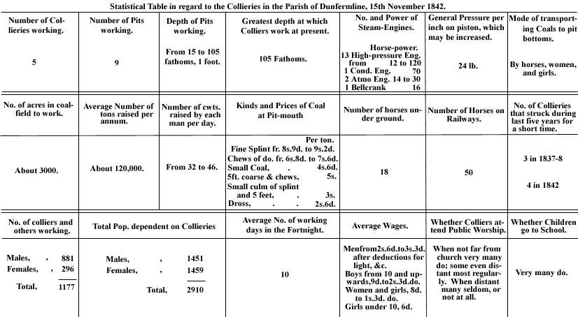 |
| Statistical Table |
-----------------------------------------------------
"Dunfermline Press"
4 January, 1913
DUNFERMLINE A CENTURY AGO.
A NETHERTOWN-CHARLESTOWN CANAL.
HOW BURGESSES OBTAINED CHEAP COALS.
Amidst all the schemes which have been propounded in connection with the new town
which is to arise in the near future within the borders of Greater Dunfermline, there is one of
which nothing has been heard for some months, namely, the construction of a commercial harbour.
In 1880 the shipments of coals from Charlestown reached a total of 196,869 tons; 1912 will close with
the total at something near 11,000 tons. The late Bailie Thomas Blair used to speak of the days when
the masts of the sailing vessels lying in "Charlestown Harbour" presented all the appearance
of a forest.
Charlestown "forest" has become a dream and a memory. In these days of big docks and
great steamers, Charlestown is gradually dropping out of sight as a coal shipping port. When the new
town (with its 30,000 inhabitants) has sprung up on the slopes lying between Castlandhill and the ancient
Abbey of Dunfermline will the desire for a commercial harbour have become so strong that attention will
be directed to Charlestown? Time alone can tell.
A DUNFERMLINE AND FORTH TRADE.
Long before the days of railways two boats plied regularly between Crombie Point and Borrowstounness with passengers and goods. The larger of the two boats was built by the manufacturers of Dunfermline for the purpose of transporting linen goods to the south side of the Forth, and from there they were shipped to London. To Crombie Point the goods were conveyed on horseback.
A BOLD SCHEME.
At the time (1793) the Crombie Point boat was running a scheme to construct a canal from Nethertown to
the Forth, near the lime works at Charlestown, was seriously considered, "shopkeepers and manufacturers
feeling that the great distance from the sea was a disadvantage."
A writer of the times says:- "Should such a canal be formed many advantages might accrue to Dunfermline as a
place of trade, and much expense be saved in the conveyance of coals for exportation. Foreign wood might likewise
be brought at an easy rate to Dunfermline, and the neighbouring parishes supplied with the commodity at considerably
less expense."
However much the commercial men of the city of 1793 may have thought the canal scheme practicable the project
never got beyond the agitation stage, and it was ultimately chopped.
A GLANCE AT LIMEKILNS.
In the closing days of the eighteenth century Limekilns and Charlestown people owned so many boats that when the
craft were driven by stress of weather to seek shelter in the bay near Brucehaven the masts looked like a small "forest".
Four brigs, one schooner and thirty-seven sloops bore legends connecting them with Limekilns, and one brig and sixteen
sloops sailed from Charlestown. Considerable quantities of Dunfermline and West Fife coals were at one time shipped from
the harbour of Limekilns, but by 1800 Brucehaven had become the popular shipping port, and the old harbour became
as much deserted as the ferry at Crombie Point is today.
Dr Barbeerie gives us a delightful glimpse at the Limekilns of other days. He says:- "Limekilns is a large seaport with a
population of 1000. Down to 1825 it was able to boast of an extensive shipping of coal; of having built during that year
ten vessels belonging to the village, from the sloop to the brig; of having other twenty-six that went to the coasting and
foreign trade; with a Marine Insurance Company, established in 1815, for their mutual protection by land and sea, with
a capital of £14,000.
They had, moreover, a large ship-building yard employing 160 men and boys; an extensive brewery that made the
far-famed Elgin ale; a malt barn, and was the landing place for the Alloa and Stirling steamboats.
It has an excellent harbour, admitting vessels of 300 tons at stream tides."
If the Charlestown harbour of today presents a striking contrast to the busy harbour of the days when the genial Bailie
I have already quoted lived at his "marine residence" on the fringes of the Forth, how much greater a
contrast does the deserted Capernaum pier present when compared with the days pictured by Dr Barbeerie show?
Dutch sailors have ceased to cry for "Mynheer" coals from the Dunfermline pits, and men attired in blue
clothes and smoking the finest cigars from foreign parts no longer slocken their thirst with the "far-famed Elgin ale."
From a busy coal shipping port to a quiet retreat for summer visitors was a great change for Limekilns.
The change consequent upon the construction of the Naval Base promises to be quite as great. The quiet
resting-place for the faded city toiler is destined to become one of the residential spots of the Rosyth worker.
THE DUNFERMLINE PITS OF 1793.
Writing of the "advantages and disadvantages" of Dunfermline 1793, the ministers of the parish tell us
that the "great abundance of coals, the short carriage, and comparatively easy rate at which coals can be
purchased render Dunfermline highly favourable for carrying on extensive manufactures. Coals may be had at half
a mile's distance. The inhabitants have the privilege of being served with coals at a hill belonging to the town
at a cheaper rate than they are sold to the country at large. At present they may have 4½ cwts. of coal on the
hill at 7d, or laid down at their doors for 1s, the carriage being 5d."
Despite the fact that the burgh coalfield was yielding a poor return, the custom of supplying cheap coals to residents
was continued up to the days of Fernie in 1815.
Fernie writes:- "At the Townhill Colliery - the property of the borough, and about a mile and a quarter distant
from it - the public are served with great coal at 7s. 6d. per ton, and burgesses have the same quantity at 5s. 5d."
The load of 4½ cwts. of 1793 was a very light one, but writers tell us that the roads "were terrible", and
the pit was worked in such a fashion that carters had often waits of hours before they could get service.
"THE GOOD OLD TIMES."
At the time the burgh coals were being sold to the Dunfermline burgesses at 5s. 5d. per ton, the poor miners who
were digging the mineral were slaves. An emancipation Act was passed in 1775, but the Act only applied to youths
who entered the mines after 1775. The result was that things remained much as they were at many collieries, and the
toilers were apt to be bought or sold with the gearing when the pits changed hands.
A complete emancipation Act was passed in 1799, and the colliers in the Dunfermline district hailed the advent of better
days with rejoicing. In the Collier Row (Bruce Street) flags were unfurled, and at all the pits in the western district of the
county there were evidences of rejoicing.
Reflecting on the days of bondage, the wretched conditions under which miners worked underground, and the small
wages, Mr Birrell, the Chief Secretary for Ireland, used often to protect against the olden time being spoken of as "good
old days". He stigmatised them as "bad old days". As applied to certain classes and their condition, the
days were "bad", but the burgesses of Dunfermline had evidently "good old times". Not only did they
enjoy cheap coals, but if the minutes of the Town Council can be credited, some of them had a high old time of it now
and again at the burgh's expense.
At a meeting of the Town Council, an account sent in by Mr Duncan McLean, innkeeper, was submitted. Duncan's
account reached the enormous total of £162, and without discussion the city fathers gave instructions to the Chancellor
of the Exchequer to "pay the bill immediately". A bill of £162! And yet there was not a single trip to London
included in it.
AN OPPOSITION COLLIERY.
Even in these "good old days" a Mr Syme came to the conclusion that "opposition was the life of trade", and he set up an opposition colliery at Venturefair. Having a royalty to pay, Mr Syme was not able to tempt the burgesses of the city with cheaper coals than they obtained from the burgh coal work at Townhill, but instead of a cheap price he offered special facilities for obtaining a supply of the Venturefair "black diamonds". In place of trundling small quantities in carts along an almost impossible road, he laid down a tramway from Venturefair Colliery to Knabbie Street, and in a depot in the centre of the street he gave Dunfermline people the opportunity of purchasing fresh drawn coals at 7s. 11½ d. per ton. Why Mr Syme broke the 8s. by a halfpenny it is impossible to say at this date. It is more than 80 years since the Knabbie Street coal depot was closed, and with the closing there came the lifting of the tramway, which was quite a mile in length.
CHARLESTOWN RAILWAY.
In constructing a tramway Mr Syme was only following the example of Thomas, the Seventh Earl of Elgin, who in 1812 completed a railway from Nethertown to Charlestown. This railway was extended in 1821 by the construction of two inclined planes to the collieries to the north of the burgh. All the coals shipped at Charlestown and Brucehaven from Elgin and Wellwood collieries were conveyed by the Nethertown railway, and in busy seasons from 20 to 30 horses were at work. With the opening of the West of Fife mineral railway, the horse waggon way was abolished, but the Coal Road, which formed the link between Nethertown and the line connecting the pits, retains its old name, and around it there still lingers echoes of the days that are gone, and when the mining industry was carried on under different conditions from the present.
-----------------------------------------------------
"Dunfermline Press"
22 March, 1930
COAL SEAM IN MILL STREET. - The excavating operations in connection with the widening of Mill
Street have disclosed the presence of a seam of coal. It is outcrop coal, nine inches in thickness, and
was found in the embankment about sixteen feet from the surface.
Many years ago, when the ground was being prepared for the erection of the western portion of the
warehouse premises of St Margaret's Works, adjacent to Mill Street, a similar discovery was made.
-----------------------------------------------------
"Dunfermline Press"
17 January, 1931
TOWER BRIDGE OPERATIONS.
DISCOVERY OF OLD COAL MINE.
In course of the excavations for the foundations for one of the
abutments in connection with the construction of the Tower Burn
Bridge an interesting discovery was made this week.
The workmen were engaged on the western embankment when
they encountered soft material, which, on being removed, disclosed
the presence of an old coal mine.
The mine is about four feet square and there are traces of a perpendicular
shaft, extending to about ten feet and thereafter branching off towards the
south. On the sides of the mine there are ample indications of the presence
of coal, and at one point there is disclosed a seam of about three feet in thickness.
It may be that what has been discovered is a relic from the days when the
monks of Dunfermline, under a Royal charter dated 1291, worked the coal
seams in Pittencrieff Glen.
On the other hand, it is possible that the discovery has some connection with
the old "Tollbooth level or mine mouth", from which, according
to the original fen-charters, the owners and occupiers of dwelling-houses
on the east side of Chalmers Street were entitled to draw water.
-----------------------------------------------------
"Dunfermline Press"
28 February, 1931
COAL WORKING IN DUNFERMLINE.
OLD MINES ON THE BANKS OF THE GLEN.
INTERESTING CITY RECORDS.
The discovery of the mouth of the old coal mine on the eastern banks of the
Tower Burn in connection with the digging of foundations for the new bridge
is interesting as throwing light on the system of mining in and around the city of
far off days.
If a new coalfield is discovered in these modern days, two shafts adjoining each
other are sunk in the "stomach" of the seams and fitted with
machinery for pumping the water and for raising the coal to the surface.
In olden time, when the monks of the Abbey and the Monastery worked
coals for the religious houses, or the miners resident in the "Colliery Raw"
and the "Rotten Raw" were "slaves" of the burgh, there
was an almost entire absence of machinery about the mines.
The digging and transport work was done by the human machine, and
drainage was accomplished by running the mines in level through the
crop coals from the banks of the burn.
VENTUREFAIR FIELD.
Readers must not run away with the idea that the Tower Burn
only afforded drainage to the mines opened and worked by the
ecclesiastical fathers of from four and a half to six and a half centuries
ago. In the "Old Statistical Account", dated 1794, the
minister of the parish states that the Venturefair coalfield, belonging
to the burgh, is being operated upon.
Both the Venturefair and the Whitefield coal areas "are worked
level free", and "contain an immense quantity of excellent coal."
"Level free" means that the Venturefair field was drained
by a mine run through the strata, and the chances are that the seam
which was laid bare the other day in connection with the new bridge
was the same seam as that worked at Venturefair.
There would certainly be a considerable flow of water at the Tower
Burn end of the mine which led into the Venturefair field.
CITY SURROUNDED BY COLLIERIES.
At the time the Venturefair Colliery was in operation the city was
surrounded by collieries. The Pitfirrane coalfield was worked by the
Halkett family as far back as the beginning of the sixteenth century.
On the walls of the library of Pitfirrane there are several charters.
One of the valuable documents is a writ of a Licence by Queen Mary to
"Patrick Hakket of Pitfyran to sell the smydde coal, and transport the
same out of the Kingdom."
The privilege was renewed by Queen Anne on 21st December 1706,
and was ratified in the United Parliament, London, on 21st March, 1707.
In the year 1788 the Government purchased the original privilege for
the sum of £40,000 sterling.
The Halkett family worked three seams, five feet, four feet, and two feet
thick, with great enterprise in an area lying between Dunfermline and
Crossford, and in the last quarter of the eighteenth century the Carron
Company had sixty operatives employed in working an ironstone seam
in the same district.
A remarkable geological feature of the three coal seams was the fact
that the lowest seam was originally struck at a depth of seven fathoms
and in no part of the field did it get beyond forty fathoms from the surface.
While the proprietor of Pitfirrane and the Carron Company were hauling
considerable outputs of coal and ironstone, operations went on to a
limited extent on the Urquhart and Pittencrieff coalfields.
THE EARL OF ELGIN'S ENTERPRISE.
Limekilns takes its name from the vestiges of old limekilns which
may be traced along the shore. The "Auld Grey Toun" of
Dunfermline was built from stone drawn from the quarry on the shore
at Rosyth, and the lime was produced in the kilns at Limekilns.
Thomas, the seventh Earl of Elgin, to whom the country is indebted
for the Elgin Marbles, launched a great scheme of lime work extension.
In 1777-8 he commenced to build nine large draw kilns, a harbour at
Charlestown, and the village of Charlestown.
The undertaking even in the last quarter of the eighteenth century
meant an outlay of from £15,000 to £20,000.
In 1793 as much as 90,000 tons of limestone were quarried and
200,000 bolls of "mistocked" lime, and 40,000
chalders of "stocked" lime were manufactured.
Large quantities of the lime were shipped to the coast towns
on the Forth and the Tay. During the summer months as many
as from thirty to fifty ships lay in the harbour awaiting cargoes.
Employment was given to upwards of 200 operatives.
The Elgin Collieries were opened in West Baldridge and Rosebank
districts, and ultimately the Elgin family constructed a railway from
the pits to Charlestown, and Charlestown became a real
shipping port, as well as a great lime shipping centre. Coals
were also shipped at Brucehaven and Limekilns.
OTHER COLLIERIES.
In 1793 collieries were also in operation at Wellwood, on
the burgh lands at Townhill, and at Halbeath. In these latter
days a good deal is heard about the coals exported from Fife
collieries. In the thirties of last century the Elgin-Charlestown
railroad was linked up to Wellwood Colliery, which was leased
by Mr James Spowart, and a considerable percentage of the
output was conveyed to Charlestown and shipped coastwise,
or to the Continent of Europe.
Mr Spowart paid as much as 2s 2d per ton as railroad rates; the
distance was nearly six miles. As many as 24 horses were
employed on the railroad, and in busy times, when ships were
arriving from the Baltic and other foreign parts, work went on
night and day, and sometimes 500 tons of coal were conveyed
from the pits to the shipping ports in twenty-four hours.
AN EIGHTEENTH CENTURY DISCOVERY.
During the summer of 1771 the mouth of an old coal mine
was discovered in the field between Pittencrieff Street and
Golfdrum through a fall of earth. Several persons ventured to
enter the mine, and travelled to a point where coal had been "gotten".
To their surprise the explorers discovered the body of an old man. A
pick and shovel lay near him. As the air began to play upon the
body of the old toiler, it crumbled to dust.
A great deal of speculation was indulged in as to how this man
had become entombed. The mine had evidently been blocked by
a fall of rock, but how the man had been overlooked by the lessee
of the coal, and by his fellow-workers, it is impossible to say.
Judging from the condition of the body, the sides of the mine
had collapsed perhaps a century before the discovery was made.
THE NAME BRUCE STREET AND THE MILL PORT.
In very old documents different spellings are given to the name
by which the street stretching from Bridge Street to the Mill Dam was
known. In one document it is written of as the "Collyeraw", in
another the "Collyier-raw", and in a third "Coallieraw".
The Gaelic word, "Coil", which means a wood or forest,
may throw some light on the origin of the name, recalling days "when
wild in woods the noble savage ran." The name of the
street was changed to King Street, and ultimately to Bruce Street.
The Mill Port stood at the top of the street. It was called the Mill Port
because the eastern side of the arch sprung from an abutment in the
west gable of an old mill which stood until 1824. The Port was
removed in 1754. An old quatrain reads as follows:-
"The auld room's mill-porte bow
Had in it stronglie sett
A great muckle oaken dore,
Ance used as its yett."
-----------------------------------------------------
"Dunfermline Press"
9 May, 1964
Dunfermline Monks Dug Coal in 1291
Fife's first coalmasters were the monks. Dunfermline Abbey was given the right to dig coal in Pittencrieff Glen as early as the thirteenth century, and it appears from the earliest notices of coal-mining that the ecclesiastical fathers had for several centuries a considerable interest in coal.
This right given to the abbot and convent of Dunfermline is in the Register of Dunfermline and is the oldest Coal Charter in Scotland. It appears that coal was dug at Tranent in 1285, but Dunfermline coal had become subject for a charter in 1291. In that year, William de Oberwill, proprietor of Pittencrieff Estate, granted a charter to the abbot and convent of Dunfermline, bestowing on them the privilege of working one coal-pit, wherever they chose, on any part of his property, except the land which was arable, and when one was exhausted, of opening up another at their pleasure, as often as they considered it expedient, but for their own exclusive use, and with an express prohibition to sell coal to others.
Chalmers, in his "History of Dunfermline," written in the forties of last century, says traces of these operations still exist in the coal waters or old excavations which have been found in the Pittencrieff Quarry.
Early in the reign of James II, the poet and scholar Aeneas Silvius, who afterwards assumed the purple under the name of Pius II, visited Fife and saw poor people begging in rags at the church doors. For alms, they were given pieces of black stones with which they went away contented. The "black stones," the Pope-to-be explains, were "impregnated with an inflammable substance" and the people "burned them in place of wood."
In the three-quarters of a century which elapsed between the visit of the Papal Ambassador and the tour through the "Kingdom" by Hector Boece in 1526, considerable progress had been made in coal production. The output of coal was now sufficient to permit supplies for other than household purposes.
Boece says – "In Fiffe are won black stanis quilk hes sa intolerable heit quhen they are kendillit, that they resolve and meltis irne, and are therefore richt profitable for operation of smiths, and such artificers as deal with other metals."
OUTCROP COAL
In those days coal-winning was a primitive occupation. Only outcrop coal could be won on the shore or in the banks of streams, drainage being effected by following up the coal-getters with trenches. When the trenches became too deep, shallow pits, or "sinks" as they were called, were put down on the levels at intervals for the purpose of supplying fresh air to the workings. When the workings reached below the level of the mine they were either abandoned or the "dam and lave" system adopted. The latter method was a laborious business. At the point where the dip began a clay dam was constructed, and over this embankment the water which had gathered at the "face" was lashed or laved with a scoop.
With a steady rising demand from Fife's numerous salt pans and metal industries, the search for coal became widespread in the county, as Fife County Council discovered to their cost some 18 months ago. Just after building operations had begun on the Council's latest housing scheme at Kincardine, the site was found to be a warren of shallow workings from which coal had been taken by the monks probably early in the sixteenth century.
DERTH OF FUEL
By the middle of the fifteenth century the coal that could be worked by the primitive methods then available was near exhaustion. There was "a maist exorbitant derth and scantiness of fewall," and in the reign of Mary Queen of Scots an Act was passed prohibiting the exporting of coal under severe penalties.
But the crisis brought forth the man, as it has done ever since in the history of the coal industry. Previous to the Reformation of 1560, the minerals in the west of Fife were worked by the abbot and fathers of Culross Abbey. In 1575, a lease was granted to Sir George Bruce, an ancestor of the present Earl of Elgin, by the Commendator of the Abbey.
A paragraph in the historic document reads as follows:-
"To our worthy friend and cousin, George Bruce, for the great regard we bear him, for the special care he had of our affairs when we were abroad in France, for his great knowledge and skill in machinery, such like as no other man has in these days; and for his being the likeliest person to re-establish the colliery of Culross, which has been long in disuetude, insomuch that we have neither large nor small coal for our own house fire."
Sir George soon proved "his knowledge and skill in machinery" by creating a colliery which became the mining wonder of Scotland.
-----------------------------------------------------
"Dunfermline Press"
24 September, 1966
Danger Of Disused Pit Shafts
Dunfermline District Council this week took action following a six-year-old boy's fall down an 80-foot disused pit shaft at Berrylaw. The Council agreed to take the appropriate steps to find out who was responsible for this and other disused pit shafts in the district after they had been described at Tuesday's meeting as "death traps." …
-----------------------------------------------------
An Urquhart shaft location
Leave Dunfermline by road to travel towards Crossford, and when you are descending the first hill, just beyond the 30 mph signposts, carefully glance over the wall on the left hand side. Around 50 yards before the dip in the road by the cottages, there in the field you will see the location of an early Urquhart Colliery shaft with its surrounding brick wall in near-perfect condition.
M. Martin & Webmasters
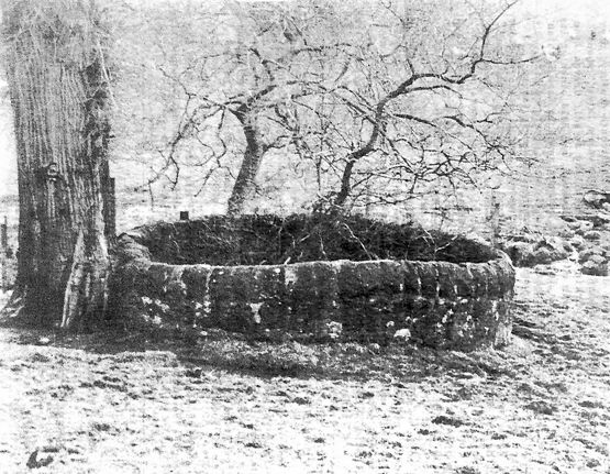 |
-----------------------------------------------------
Day-Levels in West Dunfermline
We are presently working on an article dealing with the many day-levels in Fife. This will appear in the Coalfields menu.
M. Martin & Webmasters
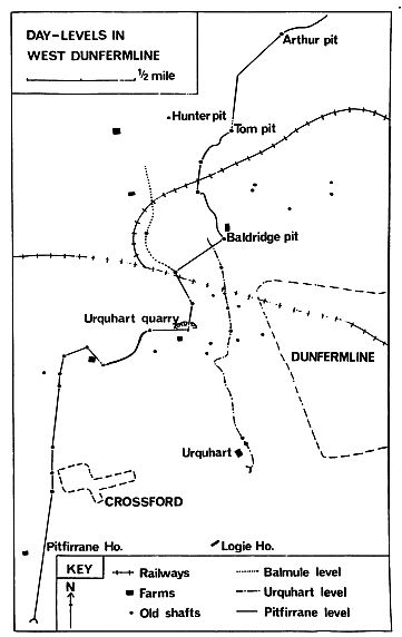 |
-----------------------------------------------------
