Owners: J. Balfour, Esq.
| See Balbirnie
Colliery entry (East Fife Index)
for fuller details of the old workings of this very important, early Fife coalfield, close by Markinch. |
|---|
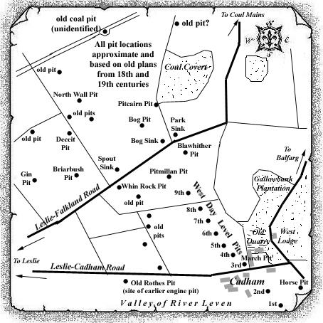
Pitcairn Coal Pit, with its engine house, features on the OS map of 1856 by the south-west corner of a lightly-wooded area known as Coul Covert. Located less than ½ mile to the east of Pitcairn farm, there were another four, as yet unidentified, coal pits, all within ¼ mile of this engine pit which would appear to have been sunk in the final years of the 18th century. A plan copy (low quality) of Balbirnie Coal Workings (1872) would appear to show the extent of the underground workings, and the locations of two air pits at Pitcairn Pit. A round pit of 5½ ft. diameter, it was close to 10 fathoms deep, and may have operated until 1880.
 |
 |
| Source Date of Information Supplied | |
|---|---|
| Manager / Under-Manager / Men underground / Men above ground / Coal seams worked / Shaft Details | |
| 1873 (John Balfour) | |
| John Oswald /
---------- / -- / -- / Upper Coal / D'cast (5½
ft. dia.) 60 ft. : U'cast (5½ ft. dia.) 70 ft.
Furnace ventilation. |
|
| 1874/75 (John Balfour) | |
| John Oswald /
---------- / 17 / 2 / Little Coal / D'cast (5 ft.
dia.) 54 ft. : U'cast (5½ ft. dia.) 60 ft.
Furnace ventilation. |
|
| 1876 (John Balfour) | |
| John Oswald /
---------- / 13 / 2 / Little Coal / D'cast (5 ft.
dia.) 54 ft. : U'cast (5½ ft. dia.) 60 ft.
Furnace ventilation. |
|
| 1877-80 (John Balfour) | |
| John Oswald /
---------- / --- / --- / Little Coal / D'cast (5 ft.
dia.) 54 ft. : U'cast (5½ ft. dia.) 60 ft.
Furnace ventilation. |
|
| The Pitcairn Pit would appear to have ceased coaling in 1877 although it was still listed in colliery records in 1880. | |
| Plan of Abandoned Seams for Pitcairn Pit | Pits or Mines designated in Plan |
|---|---|
| COAL; Main (1796) |
PITCAIRN
[Plan Custodian: Wm. Marshall, Sweet Bank, Markinch] |
| COAL; Main; Upper; Under; Little (1884) |
BALBIRNIE
Blawhither; Brierbush; Bye; Dryhouse; Engine East; Engine West; Haugh; Leven; Pitcairn; Pitmillan; Quarry; Roadside [Plan Custodian: Wm. Marshall, Sweet Bank, Markinch] |
--------------------------------------------
Statistical Account of Scotland : Parish
of Dunbog : Fife
July, 1836
Fuel. - The only fuel used in this neighbourhood is coal, which is driven from the mouth of the pit. The nearest mines are those of Coul and Balbirnie, about nine miles distant. The fuel from both is good, and the price is moderate.
--------------------------------------------
