This shaft, located ½ mile of the Brewsterwells Colliery, is being referred to as 'Northbank pit' until more details of this coal-work emerge.
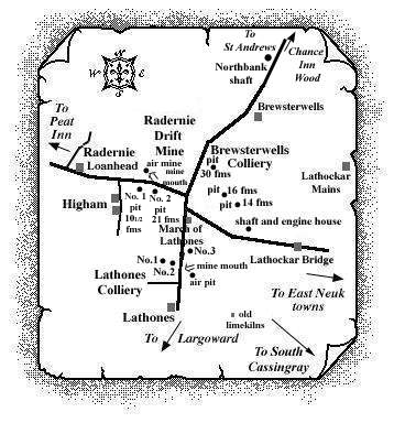 |
Information on coals worked at, or near, Northbank pit
A report from 1900 describes a coal of around 3 ft. thick,
dipping to the north-west at 12o, being
encountered at 14 fathoms in this shaft. The coal seam (Main
or Marl Coal?) is said to outcrop on the south-east side of
the Largo-St Andrews road, the opposite side of the road from
the site of the shaft.
A report from 1977 comments that subsidence was noted near
this shaft location in 1937.
The coalfield around Brewsterwells
The great dislocation which truncated the Largoward coalfield on the north was a far more powerful fault than any of the others of that field. It completely cut off all the coals in their northward extension and brought in another group of coal seams and an entirely different geological structure - the perfectly distinct Lathones and Radernie coalfield which ran in a north-westerly direction between South Cassingray and Higham.
