Eleven pits, some dating from the 18th century, are
believed to have formed the nucleus of the old Lathallan
Colliery which was in, and around, the grounds of Lathallan
estate, just south of Largoward, on the Leven - St. Andrews
road.
Other pits, to the north of Largoward, are believed to have
been worked for some time as 'Lathallan pits' under
the ownership of Thomas Brown (see below) but are not
numbered in this group of eleven workings.
Note: The coal pit in Mill Wood, in the southern part of
Lathallan Den, just north of Lathallan Mill, is shown on a
separate map, and probably was the property of Major
Lumsdaine, the owner towards the end of the 18th century.
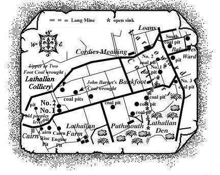
To date, only a few of these pits have been identified by
name and these appear as separate entries in the East Fife
Index - see Lathallan Nos. 1, 2 Pits and Cairn
Pits. Several old pits just to the west of the Lathallan
Splint pits formed the 'old peoples level' and
a long mine (from late eighteenth century) - running
from Lathallan Den into the Largoward coalfield - has also
been noted.
 |
 |
 |
--------------------------------------------------------------
Extracts from Statistical Accounts: Parish of Kilconquhar (1795)
"There is a considerable number of coal fields in
this parish, which have, in great measure, served the
adjacent country for some centuries past, and afford coal of
various kinds, as hard, splint, parrot, and soft, known here
by the name of cherry; and of a mixed nature, in many places;
all generally good of their kinds. The strata are subject to
many interruptions, as is the case with most of the coal in
the inland parts of Fife, being often broken off, or thrown
into different directions, by hitches as they are called,
which are of very different thicknesses, composed variously
of heterogeneous materials; the coal strata themselves also
differing in thickness, quality, stricking, and declivity;
seldom found to go much deeper than 30 fathoms from the
surface; whereas the coal strata, close by the sea, both
here, and in many other parts of our island, are said to run
for miles, almost in the same direction, and of the same
dimensions.
The coal fields in this parish that have been worked are
Balcarres coal, Kilbrackmont coal, the property of Miss Scott
of Scotstarvet, South Falfield coal, the property of Mr.
Bethune of Blebo. The above mentioned coals are not worked at
present but might afford more coal, were engines erected, or
mines driven deeper than formerly to carry off the water.
Reres coal, the property of Mr Bayne of Reres, worked by a
mine, employs 6 men, a grieve, and oversman. The price of a
cart load, 75 stone weight, is 2s. 6d.
Lathallan coal, the property of Major Lumsdaine of
Lathallan, worked by a mine, affords both hard and soft coal,
frequently of good quality; employs at present 8 colliers, 2
windlace-men, and a superintendent. The price of a cart load
75 stone weight, is 2s. 2d. ... The colliers of this
parish are tolerably regular and industrious."
--------------------------------------------------------------
Extracts from Statistical Accounts: Parish of Kilconquhar (1837)
"The great independent coal formation
characterises, throughout, the length and breadth of this
parish. ... Three well marked divisions, at different levels
and elevations ... comprise separate and distinct coal
fields, geographically as well as physically distinguished
from each other.
The first of these embraces the Grange or Earlsferry coal
field, which lies along the shore, and inclines towards the
sea; the second includes the Reres and Balcarres coal
district, inland about four miles, and elevated above the
former upwards of 400 feet. Lathallan, Largoward, and
Falfield coals, occupy the high tableland toward the northern
limit of the parish, the last attaining an elevation of about
700 feet above the level of the sea. These separations, and
elevations, of the once continuous beds of the coal measures,
have obviously been occasioned by the interposition of the
trap rocks, which occur so abundantly among them; the
principal of which are Kincraig Hill, Balcarres Craig,
Kilbrackmont Knock, Rires Craig, and Dunikier Law.
Dislocations, and shiftings, and upheavings, in every
possible form and variety, are exhibited in each of the coal
fields; but, as may be naturally expected, these curious
phenomena abound most in the upper or last division.
..."
" ... As we approach the Balcarres coal-field,
some very interesting sections may be observed, in the Den,
of an alternating series of sandstone, shale, coal, and
ironstone, and the manner in which these have been upheaved
and altered by the igneous rocks. ... Balcarres coal-field
ranges westward from the Craig, dipping partly under it, as
well as the Kilbrackmont ridge on the north. It consists of
four seams, two of which are splint, the one 6, and the other
2 feet thick. The third seam, which is 3 feet thick, consists
of common coal. The fourth is called "marl-coal",
from the circumstance of its being split up, or separated
into two seams by an interposed bed of that substance. A trap
dike of 60 yards thick traverses this field from east to
west, doing considerable injury to the minerals. The dip
varies from 11o to an angle of 20o.
Reres coal is nearly in the same line of elevation with that
of Balcarres; and has been compressed into a trough-like
form, stretching to about 800 yards across the edges of
outcrop. This curious figure into which the strata have been
thrown, terminating in a semicircular end, has unquestionably
been occasioned by the action of the trap rocks, by which it
is almost surrounded. It also consists of four seams of coal
of variable thickness.
The upper division of the parish presents coal at
Lathallan, Largoward and Falfield. ... In many places the
coals are thrown upon their edges, dip in every direction,
and at various degrees of inclination. Along with the
varieties mentioned above, a bed of cannel or parrot-coal, of
2 feet thick, occurs in this quarter. All the seams are more
or less injured in the vicinity of the dikes; and by the
shifting and upheaving of the beds, much trouble and expense
are occasioned to their respective owners."
In the parish of Kilconquhar, in 1837, 90 persons are recorded as having employment at coal works.
--------------------------------------------------------------
| Source Date of Information (Owner) |
| Manager / Under-Manager / Men underground / Men above ground [Pit/Mine] / Coal seams worked / Shaft details |
| 1795 (Major Lumsdaine of Lathallan) |
| 1873 (Thomas Brown, Largoward * and Lathallan) |
| Thomas Ireland / ---------- / --- / --- [No. 1] / Splint / D'cast 384 ft. : U'cast 300 ft. |
| Thomas Ireland / ---------- / --- / --- [No. 2] - no details except 1 non-fatal accident recorded |
| 1874 (Thomas Brown, Largoward * and Lathallan) |
| Thomas Ireland / ---------- / 120 / 19 [Nos. 1, 2] / Splint / D'cast 384 ft. : U'cast 300 ft. |
| 1875 (Thomas Brown, Largoward * and Lathallan) |
| Thomas Ireland / ---------- / 111 / 18 [Nos. 1, 2] / Splint / D'cast 384 ft. : U'cast 300 ft. |
| 1876 (Thomas Brown, Largoward * and Lathallan) |
| Thomas Ireland / ---------- / 105 / 19 [Nos. 1, 2] / Splint / D'cast 384 ft. : U'cast 300 ft. |
| 1877 (Thomas Brown, Largoward * and Lathallan) |
| Thomas Ireland / ---------- / 93 / 16 [Nos. 1, 2] / Splint / D'cast 384 ft. : U'cast 300 ft. |
| 1878 (Thomas Brown, Largoward * and Lathallan) |
| Thomas Ireland / ---------- / 80 / 17 [Nos. 1, 2] / Splint / D'cast 384 ft. : U'cast 300 ft. |
| 1879 (Thomas Brown, Largoward * and Lathallan) |
| Thomas Ireland / ---------- / 104 / 17 [Nos. 1, 2] / Splint, 5' / D'cast 384 ft. : U'cast 300 ft. |
| 1880 (Thomas Brown, Largoward * and Lathallan) |
| Thomas Ireland / ---------- / 107 / 15 [Nos. 1, 2] / Splint, 5' / D'cast 384 ft. : U'cast 300 ft. |
| 1881 (Thomas Brown & Co., Largoward * and Lathallan) |
| Thomas Ireland / ---------- / 81 / 19
[No. 1] / Splint, 5' / D'cast 384 ft. :
U'cast 300 ft.
1 fatality recorded (no details) |
| 1882 (Thomas Brown & Sons, Largoward * and Lathallan) |
| Thomas Ireland / ---------- / 71 / 13
[No. 1] / Splint / D'cast 384 ft. : U'cast
300 ft.
1 fatality recorded (no details) |
| Thomas Ireland / ---------- / 6 / 2 [No. 3] / Marl / D'cast 204 ft. : U'cast ------- |
| * This accounts for Lathallan Abandonment Plans indicating coal worked in ground to the north of Largoward. |
| 1890 (Thomas Brown & Sons.) |
| Nos. 1, 2: Thomas Ireland / ---------- / 85 / 18 / Main Splint, Soft Splint, Cherry / D'cast 480/552 ft. : U'cast 468 ft. |
| 1896 (Thomas Brown & Sons) |
| Thomas Ireland / John Raeburn / 71 / 3
[Lathallan]
Household, manufacturing and steam coals. Standing |
| Coaling at Lathallan Colliery probably ceased around 1896. |
--------------------------------------------------------------
The Lathallan Coalfield
(based on a report from 1900)
Only half a mile to the north of the little Rires
coal-basin lay the estate of Lathallan, on which coal had
long been worked, but of which the structure and relations
was still very imperfectly understood. On the north side, the
Lathallan field merged into that of Largoward, and comprised
the same seams* of coal. On the
north side of the road that ran along the northern edge of
the Lathallan grounds, the Black Coal lay at a depth of 90
fathoms. On the east side, the levels of the pits near
Pathmouth ran towards S.S.E., the strata being there inclined
towards the west. But the dip soon turned more to south-west
and south. There the field rapidly deepened towards the
south, and much higher measures may come in than anything
seen in the Largoward field. A boring which was made in 1896
close to the burn south of Lathallan House to a depth of 185
fathoms, passed through a number of coal seams, most of them
thin, to one four feet thick, which was believed to be the
Splint or Main seam of the old Lathallan workings.
It was felt at the time of the publication of the
report that further explorations should be made in this small
coalfield to determine the real position and extent of the
seams and their economic value.
--------------------------------------------------------------
Very old Lathallan coal-works
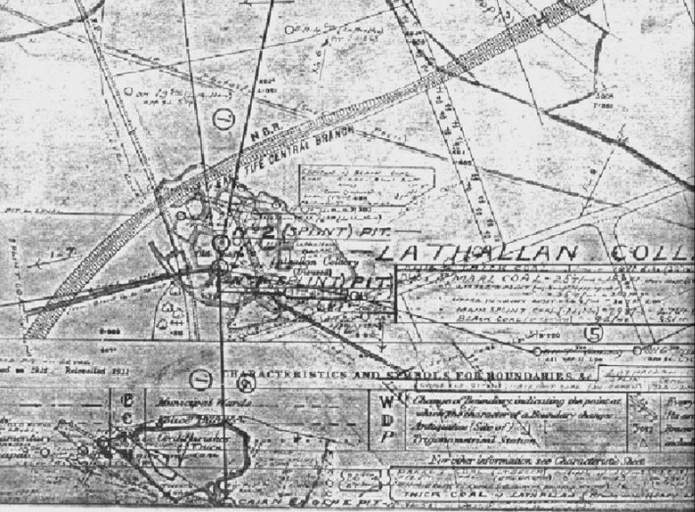
The following note has been deciphered from a poor-quality copy of a plan/map adorned with superimposed handwritten-text, lines, symbols and drawings:
Note: Mine from Lathallan Den to Lathones Parrot Coal is taken from a plan dated 1778, surveyed by Robt Mitchell of Estates of Lathones, Cordies Mealling, Largoward and Lousie Hall (sic Balcarres Ward), the property of James Durham, Esq., of Largo.
This is marked on the plan as the Long Mine along which a
number of open sinks (pits) have been put down.
Research undertaken recently [June '02] has uncovered
more information on this Long Mine - see separate index
entry.
--------------------------------------------------------------
 |
--------------------------------------------------------------
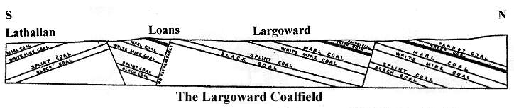
| * The section of strata in the Largoward coalfield is on site - see Coalfields link. |
|---|
At the south end of the coalfield, the inclination of the strata was, on the whole, southwards. In the pit between the mineral railway and the road that passed along the north side of the grounds of Lathallan House, the Splint Coal lay at a depth of 71 fathoms, and dipped towards S.S.E., and then to S.W. at an angle of 10°. Further east, at the pit close to where the railway crossed the high road to Kilconquhar, the same seam occurred at a depth of 64 fathoms and showed a similar inclination to south-east and south-west. It continued to strike towards north-west; until, below the road leading west from Cordies Mealling, it dipped rapidly over into another basin that lay further to the north-west. At the eastern side of this part of the field also, the dip of the strata quickly changed from S.E. to N.W., and the level in the workings swung round in the form of the letter U.
The dominant structural feature in the northern part of the field was the uprise of a dome of the strata at Bankfoot.
The Marl Coal here came to the surface, and its outcrop would have formed a fairly regular circle had it not been cut through by a fault that ran from the end of the Balcarres Ward road to Cordies Mealling.
The northern half of the dome was mainly cut off and the outcrop of the coal lay close up against the fault.
The general structure of the ground will be best understood from a horizontal section drawn in a somewhat sinuous line so as to pass over the centre of the field at right angles to the strike, as far as the south end of the Lathones igneous mass. In the northern part of the field, beyond this line of section, the structure was entirely changed by another fault.
The outcrop of Marl Coal near Cordies Mealling was quickly followed by that of the Thick Coal, and then by the Parrot seam, which was the highest of the series, but the sequence was now abruptly broken by a fault with a downthrow of 40 fathoms to the south, which ran in a north-westerly direction under the point where four roads met at the old Loans toll-bar. The effect of this great dislocation was seen by its bringing up the Splint Coal to the surface. The strata were here bent into an arch, so that from an axis passing through West Loans they dipped on the one side to north-west and on the other to north-east. Hence they swung back against the fault, getting progressively deeper on either side of the fold, until on the east side, within a distance of about 300 yards, the Splint seam was already 40 fathoms from the surface.
--------------------------------------------------------------
... and based on a report from 1977 ...
The strata between the Upper Kinniny Limestone and the
Largoward Thick Coal vary in thickness from 10 to 22 fathoms,
being the thickest in the vicinity of Lathallan. These beds
generally contain four, or locally five, coal horizons, which
are occupied by rather variable seams usually from 4 in. to 1
ft. in thickness.
Locally however, thicker coals occur: the top seam for
example is about 2 ft. thick around the shaft 200 yds. to the
north-east of Lathallan No. 2 Splint Pit. From this shaft it
was worked to some extent as "John Barnet's
Coal".
In the pit just over 400 yds. to the north of the Cairn Engine Pit, a 2 ft. 4 in. seam was worked as the Upper or Two Foot Coal: it lay about 5 fathoms above a waste taken to be that of the Largoward Thick Coal. This seam is provisionally regarded as the Smithy Coal.
--------------------------------------------------------------
| Plans of Abandoned Seams for Lathallan | Pits or Mines designated in Plans |
| COAL; Splint; Black | Lathallan |
| COAL; Black (1866-1873); Splint (1867-1883); Marl (1884); Two Feet. | Largoward |
| COAL; Splint (1883) | Largoward: Old Nos. 1, 2 , 3 |
| COAL; Splint; Black or Cherry; Marl (May, 1896) | Lathallan Nos. 1, 2 |
| COAL; Six Feet; Thin Splint; Parrot; Thick (October, 1896) | Cairn |
| COAL; Six Feet; Thin Splint; Black; Parrot; Thick; Marl; John Barnet's | Cairn |
| COAL; Upper or Two Feet; John Barnet's (1899) | Lathallan |
--------------------------------------------------------------
"The Scotsman"
10 July, 1869
FIFESHIRE.
MILLS AND MILL LANDS TO BE LET.
THE MILLS and MILL LANDS of LATHALLAN, in the Parish of Kilconquhar, Fife.
... It is expected a new Coal Pit opening in the neighbourhood will largely increase the
demand, and very possibly add to the supply of Water for driving the Machinery. ...
Lathallan, 7th July 1869.
--------------------------------------------------------------
"The Scotsman"
1 August, 1900
FIFESHIRE - ESTATE OF LATHALLAN.
To be Exposed for SALE by Public Roup ... on Wednesday, 22d August, at 3 o'clock.
The ESTATE of LATHALLAN, in the PARISHES of KILCONQUHAR and NEWBURN, about
4¼ miles from Largo Railway Station, and 4½ miles from Kilconquhar. ...
Of the MINERALS eight different seams of Coal have been worked in the Estate. One of them,
the Lathallan Splint Coal Seam, reported by the mining engineers to produce the best coal in Fife,
commanded a land sale with a demand greater than the supply. The last colliery workings of importance
ended in 1896, but boreholes put down since have found the seams at a deeper level. Since the
Colliery stopped the East Fife Central Railway has been constructed through the Lands, connecting
the Coalfield (previously worked for land sale only) with railway markets and the shipping ports of
Methil and Burntisland. Largo Ward Station (meantime for goods and minerals only) is on the
Estate. ...
--------------------------------------------------------------
Website visitor, Alan Barnet, London, got in touch with 'webmaster', Chris Sparling, in June 2019, to inform him of his search for information which might lead to him confirming a definite family link to the John Barnet's Coal worked in a few of the old pits, Lathallan Colliery, East Fife, in the late 1890s. (See above sketch map and abandonment plan for 1899.)
M. Martin & Webmasters
John Barnet's Coal
"My ancestor John Barnet lived in Cassingray, near Largoward in 1758-1839. He may have been an early miner at Largoward. His son Andrew Barnet (1805-1862) was born in Cassingray. He is known to have worked as a miner at Milesmark 1851 and also at Fordell, where he died in 1862.
I came across a reference which quoted, 'the upper, two feet and John Barnet's coal on the 11th November 1899 due to exhaustion' and I wondered if there could be a connection between my ancestor John Barnet of Cassingray and "John Barnet's coal"?
Not only were part of the Barnet family miners, but their kin - the Allan family - were also coal hewers at Baldridge, Dunfermline, in 1753. (Note: The Colliers (Scotland) Act was in 1799).
But I doubt, however, that my John Barnet is the discoverer of John Barnet's Coal. I would like to think so. The link is tenuous and I have not found, yet, any other corroborative documentary evidence.
However, your website material has provided a wealth of background for the life and times of my Fifeshire family who were actively in mining from 1753, before finally crossing the Forth to Edinburgh.
There were several of my family working within walking distance of the Lathallan Pit, but I cannot find any documented connections. One can conjecture all sorts of explanations. Perhaps he, or his son, had indeed discovered the coal seam. Perhaps one of my Johns was a testy old f**t, so they named the coal seam after him? Who knows?
My ancestor, John Barnet (ca 1780-1839) worked and lived at the Bungs of Cassingray. He died aged 81. In this period the land east of Largoward, Fife, was divided into small plots of land. John is recorded as a Labourer; that is, an employed worker, but not as a coal hewer, or collier.
At Cassingray itself there are two wells on the ordnance survey map (sheet 19: 6" 1853) one of which, I believe, was an engine pit of a later coalmine. As your maps show, the whole place is scattered with coal pits. Early pits at Cassingray may well have been Bell Pits.
John's eldest son, also John (1789-1863), lived at Lathallan lodge on the Lathallan estate. He is recorded in 1851 as a farm labourer. Lathallan lodge is 1.5 miles from his birth place at Cassingray. Lathallan lodge (sat nav KY9 1HR) is a 1-mile walk from the shafts of the Lathallan pit.
David Barnet (1799-1832), the third son of John Barnet, was a collier. He died in 1832, aged 33, at the Greigstone Pit, Nether Radernie. (2.5 miles north of Cassingray). The cause is not recorded.
Andrew Barnet (1805-1862), the fourth son of John Barnet, was a collier. He worked at the Milesmark Pit, Dunfermline (census 1851) and Fordell (census 1861). He died of phthisis * aged 56.
[* Phthisis is today recognised as pulmonary tuberculosis, but, in 1862, it could equally have been pneumoconiosis.]
The last coalminer amongst the Barnets was James Barnet (1834-1921). He was Andrew Barnet's youngest son. He worked with his father at Milesmark in 1851 (census), then he moved to Fordell in 1861, then to Wemyss in 1901 and 1911. He died of old age in Wemyss, aged 86.
Some of John Barnet's grandsons, offspring of his daughters, also entered the mining trade.
Unfortunately, the records of Fife are scarce. They were made even rarer when a boat carrying some of the official records was sailing from Fife to Edinburgh and sank in the Firth of Forth. Due to the 1606 Anent Coalyers and Salters Act, until its repeal in 1799, colliers in Fife often lived separately from the local population and gained a bad reputation.
However, mining had its rewards as a collier's pay was usually twice that of a farm labourer. But it is possible that, to improve their status, coal miners may have declared themselves in the Census's as "Ag Labs", to avoid the collier's lingering poor reputation.
I hope the above is of interest. Although the Barnet family certainly lived above the John Barnet's Coal seam, and at that time, even so, there wasn't another family of Barnets known to be living in the locality, sadly the "John Barnet's Coal" connection is still not proven. It remains an enigma.
Thank you again for you interest and information, it has been most informative. In particular, thank you for your Maps showing the pits around Largoward. I had no idea how active mining has been in the area; little remains."
Alan Barnet
--------------------------------------------------------------
