Owner: not known
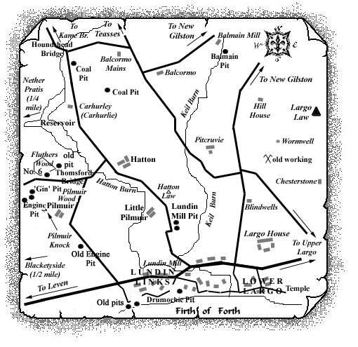
This pit was sunk on the east side of the road leading north from Lundin Mill (now Lundin Links), approximately ½ mile from this location. It is known to have worked the Carhurlie Coals in the early part of the 19th century around the same time as the two pits to the north which lay between Carhurlie and Balcormo Mains. It is not clear at this stage if this is the 'Lundin Pit' which was closing in 1867 (see separate entry).
 |
Information on coals found at, or near, Lundin Mill Pit
(Based on a report from 1900)
In the Teasses and Carhurlie coalfield, the two coals which came next above the Hurlet Limestone were worked between Hall Teasses and Nether Pratis for a distance of nearly three miles. In the old pits, the lower seam, two feet thick, consisted half of parrot and half of cherry coal. The upper seam had a thickness of 4 ft. 10 in. but included a parting of black shale 1 ft. 2 in. thick. The mining of these seams does not seem to have been disturbed by many large faults, however, the crop of the upper or main seam was interrupted by an igneous mass which lay to the north of Nether Pratis and crossed the Hatton Burn below Houndshead Bridge.

On the west side of the coalfield a good section, laid open by the Hatton Burn, between Houndshead Bridge and Thomsford Bridge, showed that the strata there were exceptionally regular with a steady south-easterly dip. The outcrop of one of the lower coals was seen just below Houndshead Bridge, and the crops of several higher seams were exposed in the same water-course further south than the seam of limestone which crossed the burn at Carhurlie.
In the early part of the 19th century, a good deal of
coal-mining appears to have been in progress around
Carhurlie. Four coal seams were known.
Of these, the lowest was 2 ft. 8 in. thick, overlain by 3
ft. of shale with 1 ft. 3 in. of good coal on top. The second
seam was 1 ft. 3 in. thick and very soft; the third, 2 ft. 6
in. thick, 9 in. being splint and the rest very slaty parrot;
the fourth seam was 1 ft. 3 in. thick.
The coal was worked between the Hatton Burn and Balcormo
Mains, where traces of these pits could still be seen around
1900. It was also mined on the southern side of the stream,
as may be seen from the remains of old pits around Pilmuir
(see separate entry).
The section in the Hatton Burn showed that the strata, after
dipping steadily at angles of from 8o to
25o or 30o to the south-east, flattened
towards Thomsford Bridge and then began to dip towards the
west and north-west.
It was felt that if the same regularity continued on the south-east, as on the north-west, of the little Thomsford basin, the Carhurlie coals should re-appear between Hatton and Lundin Mill. This indeed proved to be the case by the establishment of this pit but the coal seams worked here were cut off to the south by the huge fault which brought in the Upper Coal-Measures between Blacketyside and Largo.
... and from a 1954 report ...
According to the records of several 19th century borings
put down in the area around Pilmuir, Hatton and north of
Lundin Links, there was a group of eight coals in a total
thickness of 30 to 35 fathoms of strata. Of these coals all
but the two highest were recorded at least once with a
thickness of 2 ft. or more, and the lowest of them, locally
called the Carhurlie Coal, was known to have been
worked.
Like the other coals in the group, the Carhurlie Coal varied
greatly in its development, but it usually occurred in two
leaves separated by a foot or two of sandy or shaly strata.
The recorded thicknesses of the two leaves were summarised as
follows: lower leaf, up to 23 in. (average 12 in.); upper
leaf, 7 to 48 in. (average 28 in.).
The topmost few inches of the upper leaf were described as
rum coal, a very inferior variety of coal.
The following sections illustrate the development of the Carhurlie Coal in the Pilmuir-Lundin district.
BACK KNOCK BORE (W)
(550 yds. N.W. of Pilmuir)
| Description | Thickness |
| Light grey shale | - |
| Black Rum COAL | 6 in. |
| COAL | 2 ft. |
| Grey sandstone | 2 ft. 3 in. |
| COAL, good | 1 ft. 6 in. |
LUNDIN No. 15 BORE
(650 yds. N.N.W. of Pilmuir)
| Description | Thickness |
| Grey sand with shale | - |
| Black Rum COAL | 4½ in. |
| IRONSTONE band | 1½ in. |
| COAL | 2 ft. 8 in. |
| Sandstone, grey, with shale | 2 ft. 1 in. |
| COAL | 1 ft. 9 in. |
HATTON No. 1 BORE
(200 yds. S.S.E. of Hatton)
| Description | Thickness |
| Fakes and blaes | - |
| COAL | 2 ft. 7 in. |
| Fakes and blaes | 2 ft. 2 in. |
| COAL | 1 ft. 11 in. |
| Fakes and fireclay | 1 ft. 8½ in. |
| COAL | 10½ in. |
| Fakes and blaes | - |
MILLACRES No. 1 BORE
(about 1 mile N. of Lundin Links)
| Description | Thickness |
| Fakes and blaes | - |
| COAL | 2 ft. 6¾ in. |
| Fakes | 10½ in. |
| COAL | 1 ft. 1½ in. |
| Fireclay | - |
| Please see Stories Link: Bowman Story, for information on David Bowman, the Grand Old Man of Largo, and other Bowman family enterprises. |
|---|
