Owners: not known
| Much of East Fife's rural landscape masks its
industrial past. Many quiet pastures in our lovely
Kingdom were once scenes of coalmining activity in the
eighteenth and early nineteenth centuries. Although
little now survives of these coalmining activities which
were on a very much smaller scale than modern pits, the
fresh ploughing of a field will often reveal some
evidence in the appearance of patches of dark pit waste
from former workings. Examination of aerial photographs
of these areas can reveal a landscape covered with small
indents and markings suggesting the sites of many unnamed
old shafts and shallow workings. Often a brief mention in
an old document is the only evidence that they once
existed. Nevertheless, they too deserve to be recognised
in our record of the coalmines and pits of Fife.
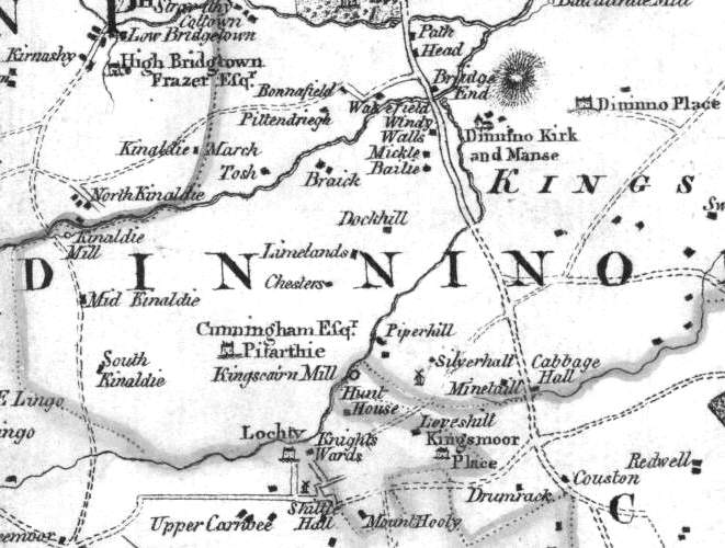
The King's Muir (Moor) region of Dunino parish is known to have been the location for a number of profitable 18th century coal mines. The map section from 1775 featuring the windmill, between Leveshill (Lovelyhill) and Silverhall, is the likely site of the King's Muir mine mentioned in early Statistical Accounts (see below). |
 |
 |
| Coal of Kingsmuir -
18th C employees
(service dates unknown) |
|---|
| Alexander Landale,
late tacksman - died 19 Mar 1766
James Landale, tacksman - died 7 Dec 1790 Robert Thomson, coalier |
Extract from Statistical Account of Fife
Dunino Parish - 1795
" ... Coal seams, from the vast number of old pits
in various places of the parish, to have, some time ago, been
a very plentiful article here. There is still, it is said,
plenty of it in several estates of this district, but it is
uncertain when any of its proprietors will open these mines,
or rather, whether their future gains would compensate the
expenditure necessary for that purpose.
... The leading subject of complaint, with the inferior
classes of our parishioners, is the scarcity of coals, (the
only article of the parish fuel), even in the land of
coal. By the selfishness of individuals, the people here
seem to be, in a great measure, excluded from those
inestimable and necessary favours, so liberally poured around
them, by the benignity and wisdom of the Almighty. For,
notwithstanding the great quantity of coals formerly raised
in our immediate neighbourhood, the spirit of monopoly has
for many years past deprived us of this bounty of Providence;
and it is hard to say how long the same spirit may continue
to afflict the poor of this parish; the principal
proprietor of the coal-mines here having entered into an
agreement with the proprietor of an adjoining colliery, to
keep his own coal-works shut till those of the other shall be
completely exhausted; in return for which the other has bound
himself, and his heirs, & c. to pay him an annuity of
£20 a-year!
Thus the poor of this parish, as well as the adjacent
country, are deprived of a blessing evidently intended for
them by Providence; and obliged to purchase fuel from a
considerable distance, at a higher price, and of a worse
quality."
" ... The estate of King's Muir is now
entailed on the name of Hanno, the surname of its present
laird, whose yearly rental amounts to £100. There is
nothing remarkable in the King's Muir, besides its
containing the coal-mine above mentioned, and one of the two
mines that convey water from the links, which was dug nearly
50 years ago, being more than 300 fathoms in length; in most
places 9 ditto from the surface of the earth; originally 18
inches wide, and 3½ feet high.
The coal here was hitherto wrought by a windmill, no vestige
of which remains; but will in future be wrought by a
different element, and by different machinery.
..."
Extract from Statistical Account of Fife
Dunino Parish - 1837
"The parish of Dunino is situated on the north-east part of the great coal basin of Scotland, supposed to be 90 miles long, and 33 miles broad. It is believed that a square mile of this space will answer the demand yearly. ... On every estate in the parish, are vestiges of coal-working at some former period; and very frequently at the surface, appears bituminous schistus or blaes, denoting the presence of this mineral. No coal is at present wrought in the parish, from a belief it would not pay the expense; and nothing is more difficult to calculate than the profits of coal-working."
Information of coals worked near Lovelyhill, Silverhall and King's Muir
(based on a 1900 report)
By the volcanic neck of Carnbee Law, the Fore and Back
Coals were interrupted and destroyed, but on the north side
of the hill, they could be traced N.N.E. as far as a fault
which ran nearly east and west by the farm at Lochty and
threw the outcrops down to the north. The crop of the Fore
Coal, with its limestone roof, was opened out on the west
side of the road 350 yds. W.S.W. from Kingsmuir House, and
the Back Coal was found at the surface 130 yds. south from
Lochty Place (now Nether Lochty).
Another fault parallel to the one just described was thought
to pass to the south of Lovelyhill and Kingsmuir House. The
outcrops of the coal are indicated by lines of old workings
between Lovelyhill and the ground to the north of Silverhall
(now Cairnscluce).
The Fore Coal was reached by a bore 400 yds. west from
Silverhall at a depth of 16 fathoms and was found to be only
1 ft. 8 in. thick and to have its limestone roof 2 ft. 2 in.
in thickness.
There was reason to believe that a large dislocation ran in
a north- west direction from this part of the district to
Kinaldy.
