Owners: Thomas Brown
Thomas Brown & Co.
Thomas Brown & Sons
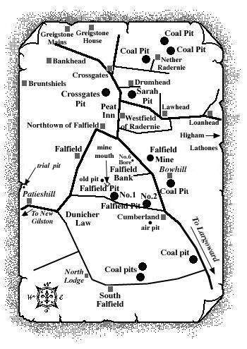
These two nineteenth century pits were located just over one mile north-west of Largoward, lying south of Falfield Bank and to the west of South Bowhill Farm (formerly Cumberland) and they were probably the last successful coal-works in this ancient coalfield (see Falfield Mine entry).
Falfield No. 1 was sunk, around 1877, ¼ mile
south-west of Falfield Bank, to the Splint or Gas Coal at 46
fathoms. An older pit and mine mouth have been identified
just a few hundred yards to the north-west of the shaft but
no details of these workings are known.
Falfield No. 2 Pit, sunk around 1881, was just over ¼
mile south-east of Falfield Bank and about the same distance
east of the No. 1 shaft. In the No. 2 Pit, the Splint or Gas
Coal was met at 25 fathoms; the Black Coal at 35 fathoms. No
details on the air pit approx. 150 yds. to the south of the
Falfield No. 2 are known but it may be the 120 ft. upcast
shaft for the pit.
These Falfield pits probably ceased coaling around 1891.
 |
 |
| Pits opened: ca 1877-1881 | Pits closed: ca 1891 |
|---|---|
| Source Date of Information Supplied | |
| Manager / Under- Manager / Men underground / Men above ground / Coals and Seams worked / Shaft details | |
| 1878 (Thomas Brown)
No. 1 Pit |
|
| Thomas Ireland /
------------ / 37 / 9 / Ell, Splint and Cannel /
D'cast (16 x 5½) 276 ft. : U'cast ----
Ventilated by furnace. |
|
| 1879 (Thomas Brown)
No. 1 Pit |
|
| Thomas Ireland / ------------ / 12 / 5 / Ell, Splint and Cannel / D'cast (16 x 5½) 276 ft. : U'cast ---- | |
| 1880 (Thomas Brown)
No. 1 Pit - Standing |
|
| 1881 (Thomas Brown &
Co.)
No. 2 Pit - Not working |
|
| Thomas Ireland / ------------ / --- / --- / Splint and Cannel / D'cast (13 x 5) 150 ft. : U'cast ---- | |
| 1882 (Thomas Brown &
Sons)
No. 2 Pit - Two shafts |
|
| Thomas Ireland /
------------ / 29 / 5 / Splint and Cannel / D'cast
(13 x 5) 150 ft. : U'cast (8 x 4) 120 ft.
Natural ventilation. |
|
| 1890 (Thomas Brown & Sons) | |
| No. 2: Thomas
Ireland / ------------ / 33 / 5 / Splint and Cannel /
D'cast (13 x 5) 210 ft. : U'cast (8 x 4) 120 ft.
Furnace ventilation. |
|
The coalfield around Falfield
This tract of ground was surrounded by large masses of intrusive igneous rock, and was so broken with faults that its detailed structure was not known at the end of the nineteenth century. It was bounded on the south by Dunicher Law and on the south-east, it merged into the Largoward coalfield. Its eastern limit was formed by the dolerite of Lathones. Its northern margin was defined by the large fault that separated it from the Radernie coalfield, while on the west it ran up to the edge of the dolerite sheets of Bruntshiels and Bankhead (see above map).
Information on coals worked at, or near, the Falfield Nos. 1, 2 Pits
(based on a report from 1900)
At the south-east corner, from a pit [the No. 2]
put down close to Cumberland farm, the Splint and Parrot seam
of the field was worked at a depth of 25 fathoms, the Black
Coal being around 12 fathoms deeper.
The level in the Splint ran nearly east and west. Some
disturbance took place further to the north, for beyond the
volcanic neck of Falfield Bank, the outcrops of the same two
seams were found again dipping to the north and traceable
westwards for nearly a mile beyond Northtown of Falfield.
The Black Coal was found on the west side of the Lathones
dolerite, in the field to the south of Loanhead. At the west
end of Lawhead, both the Splint or Parrot and the Black Coal
came to the surface and curved round a large dolerite mass by
Westfield of Radernie. That they passed under this sheet was
proved by a bore put down in a field on the west side of the
road about 200 yards south from Crossgates when, after
piercing nearly 50 feet of the dolerite, the Splint or Parrot
seam was met with at a depth of 20 fathoms.
Three quarters of a mile further north, the Splint and Black
Coals, dipping northerly at 11o, cropped out to
the east of Greigston and probably ran up against the
boundary fault. On the west side of the tuff neck of Falfield
Bank, abundant traces were to be seen of old pits*.
The Splint or Parrot and Black Coals came to the surface with
a south-easterly dip in the field to the east of Falfield.
They crossed over immediately, however, because in a section
laid open by the stream at Falfield, all the strata were
found to be inclined to the north-west.
| * See also North Falfield and
South Falfield entries
(East Fife Index) |
| Plans of Abandoned Seams for Falfield Pits | Pits or Mines designated in Plans |
|---|---|
| COAL; Main; Splint (1889) | Falfield |
| COAL; Gas; Black (1890) | Falfield Nos. 1, 2 |

"Dunfermline Saturday Press"
29 December, 1883
FATAL ACCIDENT IN A COAL PIT
An accident which terminated fatally, occurred at Falfield Colliery, near Largoward, early on Wednesday morning. Alexander Dewar, a young lad, while working near the door of the up workings, fell down the shaft a distance of ten fathoms. The poor lad was conveyed home at Peat Inn. Medical aid was speedily procured, but the sufferer survived only a few hours.
