Many of the small pits - or sinks - working the Balbirnie
coals, are believed to date from the 1600s. The earliest of
these coalworks were located by the banks of the River Leven,
close to Blinkbonnie. From here, they spread outwards, to the
east and to the west, forming "day levels" which
ran respectively towards the lands of Pitcairn, and through
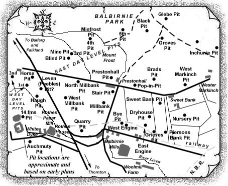
the estate of Balbirnie. The nine shafts located on the East
Day Level, through the Balbirnie Estate, are the subject of
this entry but where additional information has been
obtained, rather than just that of a numbered pit on the day
level, a separate entry has been placed in the East Index.
The first pit, close to Blinkbonnie, may have been known as
'Roadside Pit' and one source has even
suggested that this early shaft may have developed later as
the Horse Pit.
The second pit on the East Day Level may have been called
'Pit in Park'; the third pit was called the
'Mine Pit'; the fourth pit was possibly known
as 'Fire Pit' or 'Minfrost Pit'; the
5th, 6th and 7th pits appear by number only; the eighth pit
was the 'Foul Coal Pit'; and, finally, the 9th
pit is believed to have been known as 'Pond
Sink'.
 |
 |
| See also Balbirnie
Colliery entry (East Fife Index)
for fuller details of the old workings of this very important, early Fife coalfield, close by Markinch. |
|---|
-----------------
The East Day Level
coalworks
(compiled from various reports and surveys)
There are three coal seams which have been worked in the
Balbirnie area which, from the uppermost downwards, are the
Little Coal (approx. 2 ft. thick); the Main
Coal (up to 6 ft. thick); and the Under Coal
(approx. 2 ft. thick). The workings in the Little and Under
Coals appear to extend north from the banks of the River
Leven, through Prestonhall and Sweetbank into the Balbirnie
estate, the coal having been extracted on the
"Longwall" system of mining. The Main Coal,
however, seems to have been worked from the River Leven
northwards to the Tofthill Plantation at Balfarg Junction.
This coal seam, within 40 ft. of the surface in some places,
was worked by the "stoop and room" method.
The coal seams have been laid down in a synclinal basin,
with the main axis running approximately north-east to
south-west through Balbirnie House, and having side slopes to
the axis ranging from 1 in 30 to 1 in 3. The surface deposits
overlying the solid strata in this district vary from 10 ft.
to 90 ft. in thickness and generally consist of sand and
gravel, or boulderclay.
It is suggested that mining operations may have started in
the late 1600s in the River Leven valley immediately west of
Blinkbonnie junction where the overburden to the Main Coal
had been reduced by erosion. The coal was extracted by an
early form of opencast operation, removing the shallow
overburden to expose the coal. As these primitive excavations
extended into the side of the Leven valley, the overburden
thickness became too much to remove and tunnelling in the
coal followed.
This tunnel in the coal traced the contour of the seam, that
is, it followed a "level course" to avoid the
problem of flooding in the workings. This "level
course" was developed both to the east and to the west
of the original opencast excavations because of the shape of
the seam contouring in this district. These became known as
the East and West Day Levels.
| See Balbirnie & Cadham Nos. 1 - 9 Pits
entry
for information on the West Day Level coalworks |
|---|
Workings in the Main Coal from the East Day Level would be
restricted to the "rise" side of the Day Level,
again because of the inability, at that time, to effectively
pump water from the coalworks, which was drained from the
workings, via the Day Level, into the River Leven.
By the 1780s, the East Day Level had extended from the River
Leven to the west side of Balbirnie House and the Main Coal
between the Level and the west outcrop had probably been
extracted to exhaustion by the stoop and room method. Shafts
were also sunk at intervals along the route of the East Day
Level for ease of access, for ventilation and for raising
coal.
The 5th Pit along the East Day Level, perhaps from the mid-18th century, was situated at a definite turning position of this level and was sunk to the Main Coal at a depth of around 18 fathoms. The 6th and 7th Pits along this East Day Level, dated from around this same period, are thought to have been sunk to the Main Coal at depths of around 16 fathoms and 12½ fathoms, respectively.
-----------------------------------------
