Owners: probably Sir John Oswald, Esq.
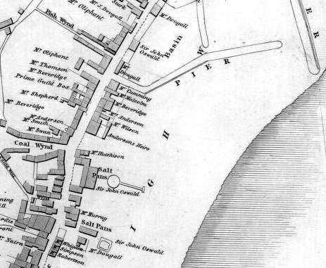
This Crop Pit features on an early 19th century map
section on land which would now be just west of Dunnikier
Road, north of Coal Wynd. Another coal pit (name not
indicated) is shown a few hundred yards to the south-east,
close to the top of Fish Wynd. Few details on these early
coal-works, other than location, have been uncovered but it
is quite likely that they worked small areas of Rough Coal as
the St. Clair Coal, and the upper leaf of the
Cardenden Smithy Coal.
Some of the pits operating in the harbour area during the
early 19th century were named the Bye Pit, the
Stair Pit and the Gin Pit.
Information on old coal workings near Bute Wynd is also being gathered in this entry until sufficient facts about these justify a separate entry.
 |
 |
 |
Information on coals worked in the southern Kirkcaldy coalfield
(based on a report from 1934)
| Also see Coalfield Link for General Section of Limestone Coal Group in the district of Kirkcaldy and Dunnikier. |
The Raith fault, with a downthrow of 30 to 35 fathoms, is
the most southerly of the major dislocations in the Kirkcaldy
coalfield; it traverses the Limestone Coal Group from the
north side of Castle Hill, north of Raith Lake, to the shore
about midway between Kirkcaldy Harbour and the gas-works.
Several minor faults, belonging to the same system, and
ranging in size from a few feet to 8 or 9 fathoms, have also
been encountered, more particularly between the Raith and
Pathhead faults and also between Begg and Muttonhall (see
Dunnikier Colliery entry); most of these smaller
fractures throw down to the north. Nowhere are they so
numerous as to present any serious obstacle to mining.
However, in the Dunnikier field, a whinstone splits into two
separate sheets, which, when traced to the south, transgress
downwards, so that first the lower sheet, in the Panny Pit
shaft, and finally both sheets, in a boring near Kirkcaldy
Harbour, come to lie below the Lochgelly Parrot Coal. It is
probable, therefore, that somewhere between these two points,
the Lochgelly Splint and Parrot coals are destroyed or
rendered valueless.
South of the Pathhead fault, which runs from Bogie Mains to
the shore below The Path of Pathhead, the whinstone sill
reappears at the surface in the railway-cutting 500 to 600
yards north of Kirkcaldy Station, where it lies just below
the Lochgelly Splint and Parrot coals, and again in a small
quarry on the south side of the Raith fault, about a quarter
of a mile west of the Station.
The Dunfermline Splint the lowest workable seam in the
district, lay 13½ fathoms above the Sulphur or Stink
Coal near the gas-works, Pathhead. It was worked under the
name 'Smithy Coal' and at one time was thought to
represent the Mynheer Coal of the Lochgelly field, a seam
which, if represented at all in this district, is rarely more
than a few inches thick.
In a bore near the mouth of the Tiel Burn, the seam is 2 ft.
10 in. thick, with a fireclay pavement and a roof of dark
fakes in which there is a thin irony rib 3 in. above the
coal. Farther north, near the gas-works and again near the
harbour, the following sections have been recorded:
Near the Gas-Works
| Description | Thickness |
| Faky sandstone | - |
| Blaes | 1 ft. 11 in. |
| COAL | 9 in. |
| Faky fireclay | 2 ft. 8 in. |
| PARROT, coarse | 4 in. |
| COAL, splint | 2 ft. |
| Faky sandstone | - |
Near the Harbour
| Description | Thickness |
| Fakes and blaes | - |
| Blaes | 1 ft. 2 in. |
| Parroty blaes | 2 in. |
| COAL, splint | 2 ft. 1 in. |
| Fireclay | 3 in. |
| Fakes | - |
In a bore at Linktown, on the south side of Ramsay Road, the Dunfermline Splint was 2 ft. 8 in. thick with a 1 in. parting near the top, and a thin irony rib in the roof which consisted of blaes (9 in.), below fakes.
The Five Foot Coal was a first-class steam coal and was separated from the Dunfermline Splint by sandy strata averaging more than 4 fathoms in thickness. In this southern part of the coalfield, the Five Foot is normally 4 to 5 ft. thick, and frequently contained one or two thin stone ribs. Its pavement was typically of sandstone or fakes, but the roof was variable. Sections of the seam proved in borings near the gas-works and near the harbour, at depths of 102 fathoms and 116 fathoms, respectively, are given below:
Near the Gas-Works
| Description of Five Foot seam | Thickness |
| Faky fireclay | - |
| COAL | 10 in. |
| Faky fireclay rib | 2 in. |
| COAL | 2 ft. 2 in. |
| Fake rib | ½ in. |
| COAL | 2 ft. 9½ in. |
| Fakes | 1 ft. 1 in. |
| Faky sandstone | - |
Near the Harbour
| Description of Five Foot seam | Thickness |
| Fakes and sandstone | - |
| Blaes | 1 in. |
| COAL | 8 in. |
| Blaes | 1 in. |
| Coaly blaes | 2 in. |
| COAL | 2 ft. 1 in. |
| Stone | ¼ in. |
| COAL | 1 ft. 11¾ in. |
| Fakes | 3 in. |
| Sandstone | - |
An exceptional development of the Lochgelly Splint and
Parrot coals was recorded in a bore near Kirkcaldy Harbour
where they were separated by almost 20 ft. of sandstone below
7 ft. of fireclay. The coals themselves, however, were of
more or less normal thickness.
The Splint was a first-class steam and household coal and was
usually about 3 ft. 3 in. thick. The roof of the seam was
formed of sandstone, except in the Seafield district where a
bed of blaes made its appearance above the the coal. The
following section was proved in a bore near the gas-works;
the Lochgelly Splint being rather thicker than usual, but
otherwise the section is fairly typical for the Kirkcaldy
district:
| Description | Thickness |
| Sandstone | - |
| LOCHGELLY SPLINT COAL | 3 ft. 8 in. |
| Faky fireclay rib | 4 in. |
| COAL | 5 in. |
| Faky fireclay | 2 ft. |
| Fakes | 2 ft. 9 in. |
| COAL | 8 in. |
| PARROT | 2 ft. 6 in. |
| COAL | 2 in. |
| Sandstone | - |
The Swallowdrum Coal was a comparatively thin seam separated from the Lochgelly Splint by 3 to 5 fathoms of sandstone and faky beds. South of the Pathead fault, it varied little in thickness, its development in the Kirkcaldy district being illustrated by the following section from a bore near the gas-works:
| Description | Thickness |
| Sandstone | - |
| Faky blaes | 2 ft. 5 in. |
| COAL | 1 ft. 4 in. |
| Coaly blaes | 2 in. |
| Faky fireclay | - |
The Jersey Coals formed a well-defined group of thin seams
included within 8 to 10 ft. of strata and separated from the
Swallowdrum Coal by about 2 fathoms of sandstone and faky
beds in which a thin coal may be developed near the top.
In a bore near Kirkcaldy harbour, the Upper Jersey was 28 in.
thick, including three ½ in. stone ribs. It was
separated by 35 in. of fakes and blaes from the Lower Jersey
which is 34 in. thick with partings of 3 in. and 5 in.
Farther south, where these coals have been proved, their
separation into an upper and a lower group was not
apparent.
The Rough Coal was the lowest seam in the Blairhall group of coals and was one of the thickest and most valuable coals in the Kirkcaldy district. It was closely overlain by the Little Splint which was rarely more than 1 ft. thick. The Rough Coal was classed as a good steam coal and was wrought extensively as the St. Clair Coal from pits and crop workings. It is believed that small areas of the coal were worked in the early decades of the 19th century, below the north end of Kirkcaldy, from old pits near the harbour, the sites of which are now built over.
The distance between the Rough and Kelty Main coals has
been proved only in a few instances; it varies from 9½
fathoms at the Panny Pits to 12½ fathoms near the
gas-works. The intervening strata are chiefly sandstone and
fakes in which two thin coals are generally developed in the
upper half. In a bore near the harbour, the distance between
the seams is reduced to 6½ fathoms by a 5 to 6 fathom
fault, which cuts the bore just above the Main Coal, and
probably throws down to the north.
South of the Pathhead fault, the Rough and Little Splint
coals have been proved only in two borings, one near the
harbour and one near the gas-works. In the latter, the Rough
Coal lies at a depth of 38 fathoms, and, with the Little
Splint, gives the following section:
| Description | Thickness |
| Sandstone | - |
| LITTLE SPLINT COAL | 11 in. |
| Faky fireclay | 4 ft. |
| COAL | 6 in. |
| Faky fireclay | 8 in. |
| COAL | 2 ft. 11 in. |
| Faky fireclay | 8 in. |
| COAL | 5 in. |
| Faky fireclay | 1 ft. |
| Sandstone | - |
In the former bore, the Little Splint is 1 ft. 9 in. thick with a 1 in. rib of parrot coal near the base, and is separated from the Rough by 8½ ft. of fakes and sandstone. The section of Rough Coal, cut at 45 fathoms, is given below in condensed form:
| Description of Rough Coal | Thickness |
| Fakes and sandstone | - |
| Blaes | 4 in. |
| COAL | 11 in. |
| Fakes and blaes | 10 in. |
| COAL | 1 ft. |
| Fakes, with 1 in. coal near base | 9 in. |
| COAL, with two ribs, 1½ and ½ in. thick | 4 ft. 9 in. |
| Fireclay | 5 in. |
| Fakes and sandstone | - |
Very little is known about the Lochgelly Blackband Ironstone in this part of the field, but it appears to be represented by a coal which has been recorded about midway between the Little Splint and Cardenden Smithy coals in a bore near the harbour:
| Description | Thickness |
| Fakes and blaes | - |
| COAL | 4 in. |
| COAL, parrot | 4 in. |
| COAL | 1 ft. 1 in. |
| Fakes and sandstone | - |
In a bore near the gas-works, 4 in. of parrot coal, with a 2 in. irony rib above it, occurs at this horizon.
In a bore near the harbour, at a depth of 24½
fathoms, 2 ft. 10 in. of 'clear waste' and 1 ft. 7
in. of 'loose rubble' resting on fireclay were
recorded below a thick sandstone. This waste marks the
position of the upper leaf of the Cardenden Smithy Coal and
is separated by about 1½ fathoms of sandy strata from
the lower leaf which is 25 in. thick with a ¼ in.
fireclay rib near the top and a fireclay pavement.
The upper leaf of the Cardenden Smithy Coal was probably
wrought at the north end of Kirkcaldy, around the 1820s, from
pits a short distance west of the harbour. As stated earlier,
these pits have long been abandoned and their sites built
over, but it is probable that the coal has been worked out
over a greater part of the area bounded on the west by the
outcrop of the coal itself, on the north by the Pathhead
fault, and on the south-east by the coastline at the
Forth.
During the demolition of a lodging-house in Bute Wynd, Kirkcaldy, an old 'stoop and room' working in coal was temporarily exposed and gave the following section:
| Description | Thickness |
| Sandstone | - |
| Fakes | 4 in. |
| COAL, clean | 2 ft. 2 in. |
| COAL, sclitty | 4 in. |
| Fireclay | - |
This coal is considered to be the upper leaf of the Cardenden Smithy. The beds are inclined to the north-east at about 15o, but there cannot be any great extent of the coal in that direction as there is evidence in a bore just 300 yards away that the seam is replaced by a spread of ash. A similar replacement is likely to have occurred in a northerly direction at least as far as the Raith fault.
An even older 'stoop and room' working was revealed in an excavation at the linoleum works of Michael Nairn & Company on the east side of Den Road, just north of Victoria Road. The following is a section of the coal taken in the working below a 9 ft. cover of sandstone:
| Description | Thickness |
| Sandstone | - |
| COAL | 1 ft. 5 in. |
| Blaes parting | 4 in. |
| COAL | 1 ft. 3½ in. |
| Fireclay | 7½ in. |
| Fakes | - |
The dip of the beds was slightly to the north of east at about 14o.
------------------------------------------------------------------
"The Scotsman"
14 August, 1882
NEW HARBOUR FOR KIRKCALDY. - There are now some prospects of a new harbour for Kirkcaldy an engineer from Edinburgh having inspected a site. Our correspondent states that the idea is to connect Kirkcaldy by rail with the Caledonian system, the line to run from Alloa down the Valley of the Tiel to the coast at Seafield, thus laying open for working on an extensive scale some of the largest and richest coal and mineral fields in Fife. At Seafield a natural site for dock and harbour works, with a good depth of water, could easily be got. The site of the present harbour is also receiving attention, as it is thought it could be made available at much less expense than Seafield. Were the old harbour scheme adopted, a line of railway would be laid along the Sands Road.
------------------------------------------------------------------
"Dunfermline Press"
16 October, 1909
KIRKCALDY AND THE SHIPMENT OF COAL
A communication has been received by Kirkcaldy Town Council from the North British Railway Company regarding the proposal to ship coal from Kirkcaldy Harbour. The letter states that it is impracticable to work shipment coal over the Kirkcaldy Harbour branch. The branch, having regard to its being a single line, and being on a gradient of one in twenty, was already fairly well taxed to overtake the goods traffic which at present required to be dealt with thereon, and it could not reasonably be used for shipment coal traffic. The question of improving the gradient had also been considered, but it was not possible to make any improvement without altering the levels of the line for a considerable distance, and it was quite impracticable, both from the point of view of cost and of the detriment that would be suffered by the main line were any such proposal carried out. The Town Council have resolved to take the opinion of counsel in regard to the town's prospects of success in the event of their making an application for facilities to the Railway Commissioners.
------------------------------------------------------------------
"The Courier"
4 February 2009
EARLY KIRKCALDY MINEWORKINGS
Mine workings dating back to the 11th century could put a higher price tag on Kirkcaldy's
sea wall project.
Drilling work has begun at the town's esplanade ahead of a proposed £8 million
project to reinforce the sea wall, which is close to collapse.
Norwest Holst contractors have been boring holes on both sides of the wall to determine how
deep the sand on the beach is and if there are any voids in underground coal seams.
The work will last around three weeks and holes up to 50 metres deep will have to be drilled
in the search for voids, which are the gaps left by coal mining.
Evidence of coal mining has been found around the town centre. Monks from Dunfermline
Abbey are known to have set up coal mines in Kirkcaldy as far back as 900 years ago.
Fife Council lead officer for harbours, floods and coasts Jim Moodie said, "There is a
capped mine shaft just south of High Street near Nicol Street and a mine was discovered
at the top of Nicol Street beside Abbotshall Road, which would have been used by monks.
The coal mines go back hundreds of years.
"If we find voids we need at least 25 to 30 metres of rock cover over the void,
otherwise we would have to consolidate the ground."
Ground consolidation work would inevitably lead to escalating costs.
Mr Moodie said, "It would increase the cost of the proposal but we're hopeful
that won't occur. We think we shouldn't have a problem but you've
always got to check these things out.
"This work has given us basic information about the rock strata. When we get to
the full design stage there will be a much larger site investigation."
In some places the sea wall is only expected to last five years before it gives way,
and there are two options for refurbishing it.
The project, led by Mr Moodie, would include strengthening the sea wall and raising it by
about half a metre, as well as introducing "rock armour" to break the waves
before they hit the wall.
Kirkcaldy Renaissance Partnership has drawn up a £50 million scheme to overhaul
the town centre, which would include more ambitious work at the Esplanade.
The partnership's scheme would include aesthetic improvements such as two piers,
and would incorporate renewable energy options such as tidal power generation.
The final decision has yet to be made, but Mr Moodie said his simpler project was the
preferred option based on a feasibility study, and £2 million of funding had
already been allocated from the council's capital budget.
In the meantime, urgent repair work is being carried out on the sea wall.
Mr Moodie said, "At some sections the sea wall only has a lifespan of five years
and we've had to carry out extensive repairs. These are ongoing."
------------------------------------------------------------------
