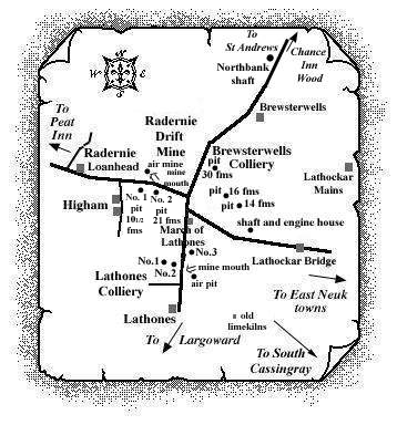
The Brewsterwells Colliery was located on the east side of
the road heading north-eastwards to St Andrews, approximately
one quarter of a mile from March of Lathones. Around five
miles south-west of St Andrews, three small pits sunk to 14,
16 and 30 fathoms, worked a different set of coal seams from
those in the Largoward coalfield only a few miles to the
south. The opening date of the 'modern' colliery, in
the district of Cameron, is believed to be around 1890; a few
years later it was associated with Drumhead Colliery to the
west. Coaling may have ceased here around 1904.
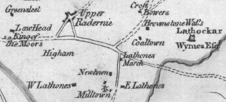
The map section from 1775 showing Coaltown near the site
of the Brewsterwells shafts, however, indicates that coal
mining had been going on in this area for some considerable
time.
No details of the shaft and engine house (on 1856 OS map),
on the north side of the road leading to Lathockar Bridge,
have been uncovered to date but it is possible it was an
engine pit of a mid-nineteenth century Higham Colliery.
 |
 |
| Source Date of Information (Owner) |
| Manager / Under-Manager / Men underground / Men above ground / Coal seams worked |
| 1890 (George Laing) |
| George Laing / ------------ / 17 / 4 [No. 1] |
| 1893 (George Laing) |
| George Laing, manager, Brewsterwells Colliery. |
| 1896 (Mitchell & Laing, Peat Inn, Cupar) |
| George Laing / ------------ / 11 / 3 [Brewsterwells and Drumhead] |
| Household, manufacturing and steam coals. |
| 1902 & 1904 (Laing Bros., Radernie, Cupar) |
| H. Laing / ------------ / 7 / 2 [Brewsterwells] |
| Household and steam coals. |
| Although linked to Drumhead, see separate entry for Drumhead in the East Fife Index |
The coalfield around Brewsterwells
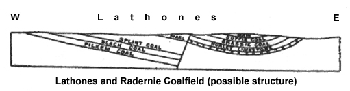
The great dislocation which truncated the Largoward coalfield on the north was a far more powerful fault than any of the others of that field. It completely cut off all the coals in their northward extension and brought in another group of coal seams and an entirely different geological structure - the perfectly distinct Lathones and Radernie coalfield which ran in a north-westerly direction between South Cassingray and Higham.
Information on coals worked at, or near, Brewsterwells Colliery
(based on a report from 1900)
The exposure of the Hurlet Limestone in the line of quarries east from the March of Lathones showed the position of the coal seams which belonged to the lowest group of the lower coals. Four seams have been worked and two of them were still being mined around 1900 on a small scale in Lathones.
About 50 feet above the Hurlet Limestone lay the Brassie (or Brasso) Coal said to have been 3 feet thick in the workings of the early part of the nineteenth century. A section met with in the later pits was as follows:
| Limestone | 4 ft. |
| Fakes (shaly sandstone) | 0 - 4 ft. |
| COAL | 2 ft. 3 in. |
| Sandstone | - |
The next seam, known as the Duffie (or Duffo) Coal, was described as 3 ft. 6 in. thick with 4 in. of shale. The following composition was typical of the 1900 workings at Lathones:
| Blaes (shale) | - |
| COAL | 1 ft. 3 in. |
| Stone | 1 ft. 6 in. |
| COAL | 2 ft. 9 in. |
| Sandstone | - |
The third seam, called the Main or Marl Coal, was 3 ft. 4 in. thick in the old pits and lay about 100 feet above the Hurlet Limestone. A fourth seam, the Cherry Coal, is said to have been worked with a thickness of 4 ft. 6 in.
As the little basin opened out towards the north, the coals on its eastern strike towards the north-east are said to have been worked formerly to a depth of 72 ft. between Lathockar and Brewsterwells.
A section to illustrate the probable structure of the Lathones and Radernie Coalfield is shown below:
| Plans of Abandoned Seams for Brewsterwells | Pits or Mines designated in Plans |
|---|---|
| COAL; Duffy; Main; Marl | BREWSTERWELLS |
| COAL; Duffy; Main; Marl (31 March, 1896) | BREWSTERWELLS |
| COAL; Brasso (17 February, 1904) | BREWSTERWELLS |
A section of Main Coal at the 30 fathom Brewsterwells Pit (1891) was recorded as follows:
| Blaes | 12 ft. |
| Coal | 6 in. |
| Coal | 4 ft. |
| Fireclay | 5 ft. |
A section of Marl Coal at the 30 fathom Brewsterwells Pit (1891) was recorded as follows:
| Blaes | |
| Coal | 1 ft. 0 in. |
| Fireclay | 10 in. |
| Coal | 1 ft. 8 in. |
| Blaes | 2 ft. 6 in. |
A section of Duffy Coal at the 30 fathom Brewsterwells Pit (1893) was recorded as follows:
| Fireclay | 9 ft. |
| Blaes | 19 ft. |
| Coal | 1 ft. 4 in. |
| Stone | 8 in. |
| Coal | 2 ft. 6 in. |
| Fireclay |
Section of strata in the Brewsterwells 14 Fathom Pit (1893)
| Section of Strata | Fms. Ft. In. |
| Surface | 1 2 - |
| Limestone | - 2 - |
| Blaes | 1 - - |
| Coal | - 1 - |
| Fireclay | - - 8 |
| Coal | - 1 10 |
| Stone | - - 4 |
| Blaes | 1 5 - |
| Coal (Parrot) | - - 4 |
| Coal | - 4 6 |
| Fireclay | 1 3 - |
| Blaes | 1 3 - |
| Coal | - 1 6 |
| Stone | - - 6 |
| Coal | - 2 6 |
| Fakes & Sandstone | 1 4 - |
| Fakey Blaes | 1 4 - |
| Limestone | - 2 6 |
| Coal (Brasso) | - 2 7 |
| Sandstone | - 4 - |
--------------------------------------
