Owners: J. Balfour, Esq.
| See Balbirnie
Colliery entry (East Fife Index)
for fuller details of the old workings of this very important, early Fife coalfield, close by Markinch. |
|---|
It is extremely rare for a single entry on the website to
represent nine pits, but these are some of the earliest pits
to have worked coals in the Balbirnie-Cadham coalfield in the
18th century, about which very little is known. They were
sunk along the West Day Level which extended from the
Blinkbonnie area in the vicinity of the old Rothes House,
roughly north-west through the fields of Cadham, and onwards
into the lands of Pitcairn, to the north side of the old
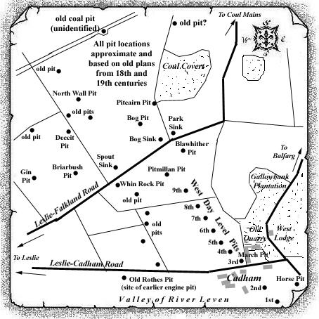
Leslie-Falkland Road. Fortunately, they feature in an old
plan of the Cadham Coal but the poor, reduced-size plan copy
which we have had the pleasure of viewing has proved
difficult to read. The approximate locations, however, have
been gleaned and have been shown on the sketch map (see
below). Where additional information has been gathered on an
individual pit, this will appear in the index as an
individual entry.
William Marshall, the custodian of the only abandonment plan
(1793) so far identified for these early coal works, resided
at Sweet Bank, Markinch, which was south of the road
bordering the southern boundary of Balbirnie Park.
 |
 |
| Plan of Abandoned Seams for Balbirnie and Cadham | Pits or Mines designated in Plan |
|---|---|
| COAL; Seam unnamed (1793) |
BALBIRNIE AND CADHAM:
Nos. 1, 2, 3, 4, 5, 6, 7, 8, 9 [Plan Custodian: William Marshall, Sweet Bank, Markinch] |
------------------------
The West Day Level Pits
of the Balbirnie-Cadham field
(compiled from various reports and surveys)
There are three coal seams which have been worked in the
Balbirnie area which, from the uppermost downwards, are the
Little Coal (approx. 2 ft. thick); the Main
Coal (up to 6 ft. thick); and the Under Coal
(approx. 2 ft. thick).
It is suggested that mining operations may have started in
the late 1600s in the River Leven valley immediately to the
west of Blinkbonnie junction where the overburden to the Main
Coal had been reduced by erosion. The coal was extracted by
an early form of opencast operation, removing the shallow
overburden to expose the coal. As these primitive excavations
extended into the side of the Leven valley, the overburden
thickness became too much to remove and tunnelling in the
coal followed.
This tunnel in the coal traced the contour of the seam, that
is, it followed a "level course" to avoid the
problem of flooding in the workings. This "level
course" was developed both to the east and to the west
of the original opencast excavations because of the shape of
the seam contouring in this district. These became known as
the East and West Day Levels.
Nine shafts were sunk at intervals along the first stage of
the West Day Level which stretched from Blinkbonnie,
in an approx. north-westerly direction, towards the
much-faulted ground by the Leslie-Falkland Road in the lands
of Pitcairn. Several small pits operated in this Pitcairn
field, on the north side of this road, but few details are
available about the workings.
The 3rd pit on this West Day Level was also known as the
"March Pit"; the 9th pit is also thought to have
been known, perhaps at a later stage, as the "2nd Room
Pit". The Pitmillan Pit and the Whin Rock Pit (also
known as North Pit) appear to be sunk on the "west day
level" to the north of the 9th pit.
-----------------------------------------
