Owner: may be Pride's old pit ?
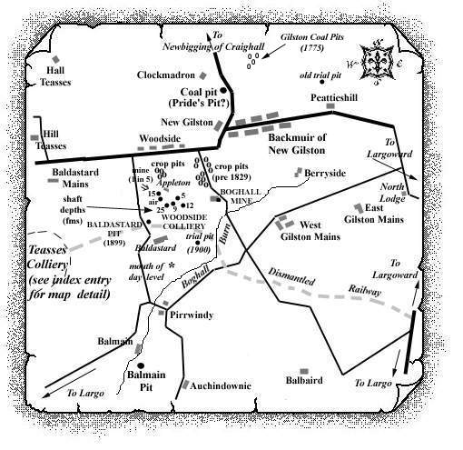
This nineteenth century working lay on the west
side of the road between Clockmadron and New Gilston. It is
known to have mined shales in addition to a range of coals,
the outcrop of the coal known as the Largoward Black Coal
thought to pass north of this 'rums' quarry near
Clockmadron. The outcrop of the Largoward Splint Coal can
also be traced with reasonable accuracy as far as the quarry.
(It is not certain at this stage if this coal-work was
known as 'Pryde's Pit' or 'Clockmadron
Pit' and so it will continue to be referred to as the
Backmuir of New Gilston Pit until this matter is
resolved.)
Largo
"The village of New Gilston is chiefly inhabited by miners."
(Westwood's Directory for Fife and Kinross 1862)
 |
Information on coals worked at, or near, Clockmadron, Backmuir of New Gilston
"The Scotsman"
26 June, 1824
ESTATE IN FIFE FOR SALE.
To be SOLD by private bargain,
THE LANDS and ESTATE of NEW GUILSTON, in the parish of Largo, containing
upwards of 440 acres, divided into convenient enclosures, and well sheltered by thriving
strips and clumps of planting.
There are two Farm Steadings on the estate, both in good condition. The turnpike road from
Kennoway, by Pratis and Fawfield to St Andrews, passes through the property, which is
situated within six miles of Cupar, the county town, and seven of St Andrews. There is
an excellent lime coal on the estate, almost inexhaustible, which is level free, and
wrought at little expense, and being in the neighbourhood of several lime works,
there is a very considerable demand for it. Nearly 160 acres of the lands are in old
grass, and let yearly for pasture.
The rental, including feu-duties, is about £600. The public burdens do not exceed £6,
and the teinds are valued and exhausted. The lands hold of the Crown, and, with the
superiority of other property, afford a FREEHOLD QUALIFICATION in the county. There
are above 30 acres covered with thriving trees of different kinds.
Mr Fyfe, at Peatieshill, will give directions for showing the lands; and, for farther particulars,
application may be made to James Kyd and Robert Taylor, writers in Cupar.
June 1, 1824.
--------------------------------------------------------------
... and based on a report from 1900 ...
At the roadside between Clockmadron and New Gilston, an
extensive opening was made in a mass of black shales, locally
known as 'rums', 150 ft. or more in thickness. This
material was used to some extent as a fuel, and was formerly
extensively employed in the burning of limestone.
Lying immediately above the 'rums' lay a seam of
coal which is said to have been "four feet thick,
two foot six inches of it being cherry, six inches 'rum
coal', and the rest good cannel coal."
At a distance of 25 ft. above the 'rum coal' lay a
second seam two feet thick, while still higher came two
additional seams each two feet six inches thick, which lay
near each other, and were worked underneath the dolerite of
Backmuir of New Gilston.
The outcrop of the thick band of 'rums' circled
round the west end of the ridge on which the village
stands.
[A Geological Survey published in 1977, however, states that the available information about the Clockmadron area is very ambiguous and the identification of the four feet thick seam overlying the 'rums' as the Largoward Splint Coal is very tentative. A thickness of nearly 20 ft. of this material is now visible in the quarry and it seems unlikely that the full thickness, of what must be a local development, exceeds 29 ft. 6 in. Estimates of thicknesses given by two earlier writers, of around 78 ft. and 150 ft., appear to have been considerably exaggerated!]
Around Hall Teasses, it was found that coals were very
foul and blind due to deprivation of bitumen. Further
evidence of the disasterous effects of igneous intrusions on
the coals was revealed by a series of borings sunk around
1896/97 in the low ground to the east. Three trials were made
in a line on the alluvial flat to the east of Hall Teasses.
Each of them stopped in "hard whinstone", which was
reached at depths varying from 7 to 24 fathoms. One of them
passed through three coal seams, all of which were blind and
thin, ranging from 10 to 15 inches in thickness.
About 450 yds. further south, on the opposite side of the
moss, a diamond drill, which was put down to a depth of just
over 105 fathoms, pierced a "whinstone" sheet 200
ft. thick, at a depth of 46 fathoms, and ended off in another
at the bottom. Three thin coal seams were encountered above
the sill passed through, and each of them was found to be
blind. The diamond bore also passed through 2 ft. 4 in. of
limestone at 88 fathoms, and another seam 10 ft. 7 in. thick
at 98 fathoms. These were obviously the lower limestones, but
the numerous and valuable coal seams which usually overlay
them were found to absent in this case.
In spite of these serious obstacles to successful mining, coal has been searched for and worked at various parts of the field, especially towards the south between New Gilston and Baldastard, at a greater distance from the invasive "whinstone". In this tract, some of the series of the lower coals were met with.
--------------------------------------------------------------
