Owners: Cochrane ?
East of Fife Coal Co.
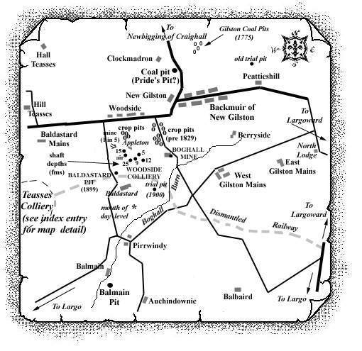
The 19th century Boghall Mine, to the east of Woodside
Colliery, may also have been known as Cochrane's Boghall
or Gilston Mains Colliery. It is reported to have wrought an
excellent 2 ft. 7 in. thick Cherry Coal seam but the No. 1
Mine was abandoned by the East of Fife Coal Company in 1890.
A number of old crop pits in the fields to the east are known
to have worked several seams of cherry, 'rum' and
cannel coals before 1829.
 |
| No. 1 Mine opened: not known | No. 1 Mine abandoned: 1890 |
|---|---|
| Source Date of Information Supplied | |
| Manager / Under- Manager / Men underground / Men above ground / Seams worked / Shaft Details | |
| 1890 (East of Fife Coal Co. Ltd.) | |
| No. 1: -------- / ------------ / 13 / 5 / ---------- / Abandoned. | |
Extract: Statistical Account
of Fife
Parish of Largo - 1791
" ... coal may be wrought to advantage. On the estate of Lundin, the coal has been cropped; but by erecting an engine near the sea, a deep seam, which stretches over upon the estate of Largo, would be opened. This would amply supply the neighbourhood, and afford besides a considerable exportation. ..."
Extract: Statistical Account
of Fife
Parish of Largo - 1845
" ... Many years ago, coal was wrought in large quantities, especially near the coast. At present, there are three seams wrought, but none of them are of the first quality. To the north of New Gilston a singular mass of rum coal is found, under the mass of overlying trap on the south. It is an inflammable bituminous shale, and is extensively used for lime-burning. It is known to be 80 feet thick, and is wrought in an open quarry. ..."
Information on coals worked at, or near, Boghall Mine and nearby crop pits
(based on a report from 1900)
Around Hall Teasses, it was found that coals were very
foul and blind due to deprivation of bitumen. Further
evidence of the disastrous effects of igneous intrusions on
the coals was revealed by a series of borings sunk around
1896/97 in the low ground to the east. Three trials were made
in a line on the alluvial flat to the east of Hall Teasses.
Each of them stopped in "hard whinstone", which was
reached at depths varying from 7 to 24 fathoms. One of them
passed through three coal seams, all of which were blind and
thin, ranging from 10 to 15 inches in thickness.
About 450 yds. further south, on the opposite side of the
moss, a diamond drill, which was put down to a depth of just
over 105 fathoms, pierced a "whinstone" sheet 200
ft. thick, at a depth of 46 fathoms, and ended off in another
at the bottom. Three thin coal seams were encountered above
the sill passed through, and each of them was found to be
blind. The diamond bore also passed through 2 ft. 4 in. of
limestone at 88 fathoms, and another seam 10 ft. 7 in. thick
at 98 fathoms. These were obviously the lower limestones, but
the numerous and valuable coal seams which usually overlay
them were found to absent in this case.
In spite of these serious obstacles to successful mining, coal has been searched for and worked at various parts of the field, especially towards the south between New Gilston and Baldastard, at a greater distance from the invasive "whinstone". In this tract, some of the series of the lower coals were met with.
The outcrop of the thick band of 'rums' worked
between Clockmadron and New Gilston circled round the end of
the ridge on which the village stands, and a line of old crop
pits could be traced in the fields to the east of Boghall.
The crop of a coal 3 ft. 4 in. thick came to the surface at
Boghall, and was cut off there, to the north, by a north-west
fault.
| Plan of Abandoned Seams for Boghall or Gilston | Pits or Mines designated in Plan |
|---|---|
| COAL; probably Dunfermline Splint (November, 1890) | Boghall or Gilston |
The Splint Coal of this part of the field was around 3 ft. thick and has also been tentatively identified as the Largoward Splint Coal which was said to be 3 ft. 3 in. thick, the bottom 8 in. being of inferior quality.
