Owners: Beath and Blairadam Colliery Company
Fife Coal Company
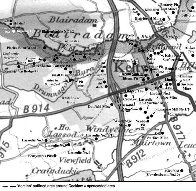
Probably sinking around 1870, Northertown (sometimes
Northernton) Bridge Pit was a trial pit located in the extreme west of
the Kelty coalfield by the bridge over the Lochornie Burn,
just east of the reservoir.
It was eventually sunk to a depth of 17 fathoms and coal was transported by
horse and cart to local users or loaded into wagons at Blairenbathie
Public Siding. The pit was taken over by the Fife Coal Company in 1872
but it closed in November 1876, along with Blairenbathie Cottage Pit, and
a trial mine, to the south, in the Splint Coal, in the general drive for improved
quality of product.
Peter Brown, the Benarty Antiquarian, maintains that
Northerntown Bridge was the pit mentioned in "The Fife
Coal Company Limited : A Short History" where the
underground workers had advance warning of a visit from the
manager, Charles Carlow, because they heard the thud of the
horse's hooves as the manager approached. At that depth
it could well have been the case!
 |
 |
|
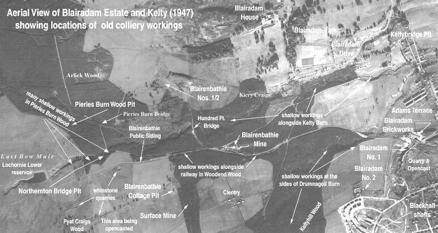
The short historical note which follows has been
contributed to explain the existence of the shallow
workings frequently mentioned in geological memoirs
from which some site information is obtained and which
are common to the excavations around Kelty Burn,
Pieries Burn, Drumnagoil Burn, Lochornie Burn, Woodend
Wood and Keltyhill Wood - all locations to the west of
Kelty.
Following the last Ice Age (about 30,000 years
ago) the land was covered by thick beds of glacial
deposits comprising sand, clays and gravels. Subsequent
streams and rivers cut through these relatively soft
deposits and exposed the solid layers of rock
(including coal) in the sides of the valleys and gorges
formed by the erosive action of the water. History
tells us that coal was most likely to be first mined
at, or near, these locations. Dunfermline Glen, Esk
Valley in the Lothians, Rhonda Valley in Wales,
Tyneside in Northumberland and the Ruhr in Germany are
typical examples.
|
Kelty Colliery (19th century report)
| Name of Coal | Thickness | Quality | Class | |||
|---|---|---|---|---|---|---|
| Main Coal | Roof Coal | > | 1 ft. 10 in. | > | Good | Bunker Coal |
| Good Coal | > | 4 ft. 8 in. | > | |||
| Jersey Coal | Coal | > | 2 ft. 6 in. | > | Good | Steam |
| Stone | > | 2 ft. 4 in. | > | |||
| Coal | > | 3 ft. 8 in. | > | |||
| Bank Coal (Lochgelly Splint) | 4 ft. 5 in. | Good | Steam and 2nd class
Household |
|||
| Dunfermline Splint Coal | 4 ft. 7 in. | Good | Best Household | |||
-------------------------------------------
Information on coals worked at, or near, Northertown Bridge Pit, Kelty
(based on a report from 1930)
Traces of old surface workings in the Five Foot Coal could
still be seen around this time in the burn south-east of
Craigencat cottage and in the north bank of the reservoir at
Lochornie, about 80 yds. from the embankment. The coal in
this shallower, western part of the Blairenbathie coalfield
was reported to be 4 ft. thick, with a roof of faky blaes and
a pavement of sandstone. Above the Five Foot Coal was a thick
bed of blaes with ironstone nodules in which lay two thin
seams of coal. The upper of these, about 15 ft. above the
Five Foot Coal, may have reached a thickness of 1 ft. 3 in.
and probably corresponded to the Pittencrieff Ironstone of
Dunfermline, and the Jewel Coal of Cowdenbeath.
In this area, the Mynheer Coal was a thin seam and, near the
outcrop, several bores recorded thicknesses of coal varying
from 1 ft. 3 in. to 1 ft. 7 in. The Mynheer Coal at
Blairenbathie was everywhere succeeded by a thick post of
sandstone which was best seen at the surface, forming the
steep banks of the Lochornie Burn to the east of the
reservoir. In this western side of the coal basin, the traces
of shallow workings also revealed that small extractions of
the Glassee Coal had taken place at the outcrop in Lochornie
Burn, west of Northernton Bridge, and from several small pits
in Northernton Wood. In the ground, the Glassee Coal averaged
2 ft. 7 in. and may have contained a foul rib. The roof was
frequently an impure ironstone and the overlying blaes
contained ironstone ribs and nodules.
In No. 1 Bore, Blairadam, just 50 yds. west of Northernton
Bridge, a 4 ft. 6 in. seam proved at the surface may have
been the Lochgelly Parrot Coal. (There is difficulty in
identifying the individual member of the Main Group of Coals
in the Blairenbathie district due to an irregular group of
intrusive whinstones at this horizon.) This seam was also
worked from several pits towards the dip.
It was poor quality coals from the Blairenbathie area which
damaged the reputation of the Fife Coal Company and
eventually led to the closure of a number of pits including
the Northernton Bridge Pit.
-------------------------------------------
| Plan of Abandoned Seams for Northertown Pit | Pits or Mines designated in Plan |
|---|---|
| COAL; Splint; Seam unnamed, at seventeen fathoms (10 November, 1876) |
BLAIRADAM LANDS:
Blairenbathie; Northertown Bridge |
-------------------------------------------
A section of the minerals passed through at Northertown Bridge Pit was recorded as follows:
| Section at Northertown Trial Pit | |
| Soft whinstone | ~ 5 fms. |
| Hard whinstone | ~ 10 ft. |
| Foul Coal | ~ 1½ ft. |
| Sandstone | ~ 4 fms. |
| Coal - very inferior | ~ 4 ft. |
| Faikes | ~ 2½ fms. |
| Coal - cherry - fair quality | ~ 5 ft. |
| Fireclay | ~ 2 ft. |
| Coal with stone and fireclay ribs | ~ 5 ft. |
| Fireclay | ~ 2 ft. |
| Coal | ~ 3 ft. |
-------------------------------------------
"The Scotsman"
2 March, 1860
MINERALS ON THE ESTATE OF BLAIR-ADAM.
TO BE LET, either together or separately,
THE COAL-FIELDS OF LOCHORNIE and WHITEHOUSE, lying on the South
and West of the Estate of Blair-Adam.
These Fields can, by means of a short line of Railway, of easy construction,
be connected with the West of Fife Mineral Railway, and with the Kinross-shire Line,
thus affording full command of Markets and Shipping Ports, both to East and West.
The Lochornie Coal-field is known to contain many valuable Seams of Coal; among
these are, an 8½ feet Seam, intersected by a very thin stratum of Freestone;
also Two Seams of 3½ feet, associated with Clay Band, Ball Ironstone, and Fire
Clay, with many other Seams not yet fully proved. The Whitehouse Field contains,
among other Minerals, a Seam of Gas Coal, with Black Band, a fine Seam of Splint
Coal, overlying excellent Fire Clay; also Two Seams of excellent quality, the one 4 feet
9 inches thick, associated with large Ball Ironstone, the other 4 feet, both of which
have been proved. In both Fields, Ironstone, Limestone, and other Seams of Coal
are known to exist, and can be proved by more extended trials.
Mr Dowie, factor, Blair-Adam, will give all necessary information, and will point out
the boundaries of the Fields proposed to be Let. Offers for a Lease may be made
to him; or to Mr GEDDES, mining engineer, Edinburgh.
-------------------------------------------
"The Scotsman"
5 August, 1870
COALFIELDS ON BLAIRADAM ESTATE.
for such periods as may be agreed on,
A series of Bores recently put down proves excellent Seams of Coal, and a trial pit is open which shows the quality and thickness of one of the Seams.
A branch line is formed and working from the Railway to the existing Pits, and a survey has been made for a extension to the Coalfields above named.
Apply to Mr DOWIE, Factor, Blairadam; or Messrs GEDDES, M. E., 9 Melville Crescent, Edinburgh, who will give particulars.
July 8, 1870.
-------------------------------------------
