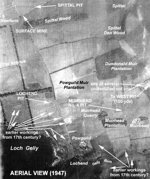
This small pit was situated a few hundred yards north of the Muirhead Farm and Plantation to the east of Loch Gelly. It was probably owned and operated by the Dundonald Coal Company from the 1890s to around 1910.
 |
 |
| See Central Fife Index Entry 'Dundonald Pits & Mines' for more details |
|---|
Coal is known to have been worked in the early 17th century around Powguild Farm and on the lands between Muirhead and Dundonald. A number of unidentified old pits are known to have been sunk in the vicinity of the West Pit which was located to the north-east of Muirhead farm (see aerial view).
Information on coals worked at, or near, Muirhead No. 4 Pit
(based on reports from 1900 and 1934)
The outcrop of the Lochgelly Splint and Parrot seams appeared on the northern shore of Loch Gelly and ran eastwards against a large fault close to the farm of Muirhead. It further progressed eastwards into the Dundonald, Cardenden and Kirkcaldy fields. It is these seams which were mainly wrought during the lifetime of this pit.
Several of the large faults from the Lochgelly coalfield extended eastwards and entered Dundonald Colliery. One of these passed a little north of Muirhead and south of Shaws Mill. To the south of it, another dislocation occurred, and between the two no coals were met with. Another east and west fault, with a downthrow of 8 fathoms to the north, ran by the north end of the Muir Plantation near Spittal farm.
In the Dundonald Colliery, the Sulphur Coal was represented only by a few inches of coaly material whereas the Dunfermline Splint was in leaves containing around 3 ft. 4 in. of coal with only the top 22 in. providing profitable mining. The Two Foot Coal was represented by a thin rib of dirty coal and coaly blaes. The Five Foot Coal lay 5 to 14 fathoms above the Dunfermline Splint with the seams being most widely separated near Lochgelly House and along the north shore of Loch Gelly where the intervening sediments were mainly sandstones. The outcrop of the coal could be traced round the southern margin of the coalfield by means of borings records and old workings from the north-east shore of Loch Gelly to Tullylumb Plantation in the east. The coal could formerly be seen in Carden Den underlying the massive sandstone on which Carden Tower was built. At Dundonald Colliery, where a considerable amount was raised under the name 'Mynheer Coal', the average thickness was about 3 ft. The seam provided a very good household coal, a representative section measured in a boring at Muirhead quarry having:
| Sandstone, faky at base | - |
| Blaes, faky | 2 ft. 11 in. |
| COAL | 1 ft. 6 in. |
| Sandstone rib | 1 in. |
| COAL | 2 ft. 2 in. |
| Fireclay | - |
The Upper Five Foot or Jewel Coal was poorly developed at Dundonald and in the Spittal farm bore, the whinstone lying above the Mynheer Coal (6 to 9 fathoms above the Five Foot) had caused this to be reduced to coaly blaes. A 20 in. coal, however, with the characteristic ironstone roof was recorded at Powguild Plantation.
Between Spittal farm and Spittal Wood, Glassee Coal appeared to be represented by a 7 in. coal resting on coaly fakes cut at a depth of 78 fathoms. No coal was found at the Glassee position in the 1906 bore at Powguild Plantation. As stated earlier, the outcrop of the Lochgelly Splint and Parrot Coals could be seen on the north shore of Loch Gelly, some 250 yds. east of the boathouse, striking towards Muirhead sandstone quarry. However, towards Powguild Plantation, the Lochgelly Parrot Coal was almost entirely destroyed by a thin dolerite sill.
The Lochgelly Splint Coal was generally more than 4 ft. thick and its roof was of fireclay or blaes overlain by a persistent seam of foul coal, locally known as the Craw Coal. A section measured near the outcrop, on the north side of Loch Gelly, gave the following:
| Blaes, faky | - |
| CRAW COAL | 1 ft. 4 in. |
| Fireclay, dark | 4 in. |
| Blaes, parroty | 8 in. |
| COAL, splint | 5 ft. 4 in. |
| Fireclay | 1 ft. 10 in. |
| Fakes and sandstone | - |
The Lochgelly Splint Coal was partly burnt in the ground just to the west of Powguild Plantation.
The Swallowdrum Coal (known in the Dundonald field as the 'Duddie Davie') was a composite seam which lay 3 to 10 fathoms above the Lochgelly Splint and in a boring in South Green Park, on the north side of Loch Gelly to the west of Muirfield No. 4, it had the following composition:
| Fireclay | 4 ft. |
| COAL | 9 in. |
| Fireclay | 9 in. |
| COAL | 1 ft. 7 in. |
| Fireclay | 4 in. |
| COAL | 1 ft. 8 in. |
| Coal and fireclay | 9 in. |
| Blaes and fakes | - |
Around Spittal farm to the north of this pit, the Jersey Coals were of little value, being usually distributed in leaves less than 2 ft. thick through several fathoms of barren strata. Borings between Newfarm and Spittal showed that the Rough Coal, at the base of the Blairhall Group of coals, generally exceeded 5 ft. 6 in. and included a number of dirt bands.
To the east of Newfarm, where a shallow pit was sunk on the seam at the west end of Spittal Wood, the following section of Lochgelly Blackband Ironstone was proved:
| Blaes | - |
| COAL, parrot | 1 ft. 3 in. |
| IRONSTONE, strong | 2½ in. |
| IRONSTONE, softer | 2 in. |
| Fireclay, light | 3½ in. |
| COAL, cherry | 1 ft. 8 in. |
| Fireclay, sandy | - |
The lower leaf of the Cardenden Smithy seam, which lay 6 to 10 fathoms above the Lochgelly Blackband Ironstone, was rarely thick enough to be worked and frequently contained a considerable percentage of foul coal. A thin ironstone rib associated with coal was recorded near Spittal farm, some 3 fathoms above the Blairhall Main Coal which lay 3 to 6 fathoms above the upper leaf of the Cardenden Smithy seam averaging around 2 ft. 9 in. and being described as an ordinary steam coal.
----------------------------------------------------------
| Plan of Abandoned Seams for Muirhead Pit | Pits or Mines designated in Abandonment Plan |
|---|---|
| COAL; Duddie Davie (1908); Fourteen Feet (1911); Lochgelly Parrot (1912); Glassee (1914); Lochgelly Splint (1920) | LADY HELEN
Den; Muirhead No. 4; North; Smithy |
