Owners: R. Forrester & Co. Ltd. (Glasgow)
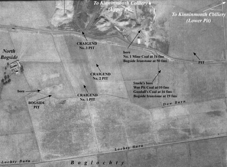
The three Craigend Pits, north-west of Kinglassie, are
represented in this single entry. These small pits, about
which little has been uncovered, were probably in existence
from around 1897 until 1909. Located in the west of the small
Boglochty coalfield, they were south-east of the
Ballingry-Auchmuir Bridge road and close to the farms of
Craigend, West Balbedie and Bogside.
They were to the south of the old pits and mines of the
Kinninmonth Colliery, and just to the east of the Bogside
Pit.
 |
 |
| Pits opened: 1897 ? | Pits closed: 1909 ? |
|---|---|
| Source Date of Information Supplied | |
| Manager / Under-Manager / Men underground / Men above ground / Coal seams worked | |
| 1902 (R. Forrester & Co. Ltd.) | |
| R. Stewart / ------------ / 6 / 6 / Household, manufacturing and steam coals. | |
| 1904 (R. Forrester & Co. Ltd.) | |
| John Duncan / ------------ / 31 / 13 / Household, manufacturing and steam coals. | |
| 1905 (Forrester & Co. Ltd.) | |
| ---------- / ------------ / 46 / 18 | |
| 1908 (R. Forrester & Co. Ltd.) | |
| William Stewart / ------------ / 65 / 23 | |
Extract: Statistical Account of Kinglassie Parish, Fife - 1791
"... There are many stone quarries and coal mines. Coal is the only fuel. The mine presently worked is esteemed the best burning coal in Fife. The coals are sold on the hill at 6d. the load, each load weighing 22 stone Dutch weight. ... "
Extract: Statistical Account of Kinglassie Parish, Fife - 1845
" ... Mineralogy.- Although, at no very remote period, coal-works were in operation, yet during several preceding years that occupation has been entirely suspended within this parish. There is reason to believe, however, that were coal pits less numerous in the neighbourhood, a copious supply of this fossil could be obtained. In various parts, ironstone, the constant companion of coal, is found. ... "
Information on coals worked at, or near, Craigend Pits
(based on a report from 1900)
The structure of the coalfield to the west and north-west of Kinglassie was difficult to understand in the nineteenth century. The coals in it did not seem to fall into any recognisable association with those of any other part of Fife, though there can be no doubt that they must be classed in the true Coal Measures. In the late 1890s, the district was explored by boring and this cast fresh light on its geological structure. Approaching the 1890s, coal mining had not been carried on with much energy, and for a while the only pit in operation (identity presently unknown) ceased to be used. Since that time the ground has been largely explored and has been opened up to a considerable extent. The coal seams of the Dysart field have been found in it, though with such variations in thickness and character and such differences in the nature and depth of the intervening strata that identifications of the individual seams with those of Dysart are perhaps somewhat doubtful. In particular, the sedimentary strata between the separate coals appear to be much thinner than in the main coalfield.
Kinglassie Colliery (19th century report)
| Coal seams worked | Thickness | Quality | Class |
| No. 1 Coal | 3 ft. | - | - |
| No. 2 Coal (Leven 6 ft.) | 5 ft. 5 in | Good | Household |
| No. 3 Coal | 4 ft. 9 in. | Good | Household |
| No. 4 Coal | 5 ft. | - | - |
| No. 5 Coal | 2 ft. 8 in. | - | - |
| No. 6 Coal (Muiredge 4 ft.) | 4 ft. 4 in. | Good | Household |
| No. 7 Coal | 4 ft. 9 in. | Good | Good Household |
| No. 8 Coal | 3 ft. 9 in. | - | - |
| No. 9 Coal
(Ironstone* & coal |
Ironstone * 1 ft. 8 in.
Coal 2 ft. 2 in. |
-
- |
Blackband
- |
| No. 10 Coal | 4 ft. | - | - |
| No. 11 Coal (Dysart Main) | 18 ft. | Soft | Inferior Steam |
| No. 12 Coal | 4 ft. | - | - |
| * This was last worked in the northern part of the coalfield around 1870. | |||
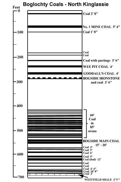 |
These coals are disposed in a synclinal trough which is truncated on the north by the great Ochil fault. Its western lip begins about 500 yards to the west of Kinninmonth Farm, where it strikes from the fault-boundary in a south-westerly direction to near North Bogside Farm, then it turns round under Boglochty and bends northwards on the west side of Whinnyhall.
Westfield Shale: Above the Millstone Grit lay a thick bed of greenish, faky fireclay containing a variable coaly layer. The fireclay was succeeded by the Westfield Shale which, in the above table, is taken as the base for the Coal Measures. The shale underlay a thick coal and has been identified over all the southern and western part of the coalfield. (Apparently, it was worked for oil-making for a few years in the 1860s and again in the 1880s with a yield of crude oil varying from 18½ to 30 gallons per ton!)
The Shale was succeeded by about 25 fathoms of strata that contained coaly matter throughout. In the southern part of the basin, a brown coal, from 5 ft. to 6 ft. thick, lay 20 to 30 ft. above the 'roof coal' of the shale. Three to five fathoms of sandy beds with thin coals succeeded this seam and was followed by a thick mass of coal and fireclay in variable beds. In the north-western part of the basin, close to Craigend, the coaly material was concentrated more definitely into seams but the quality of the coals was generally poor.
Note: In the late 1890s, it was recognised that there may possibly be another smaller basin of coal in the same field, somewhere to the south of Kinglassie, but the mineral capabilities of the ground could only be determined by boring exploration. This proved to be the case and coals in this southern part of the Kinglassie coalfield were mined at Kinglassie Pit and Mine (see separate entry).
| Plans of Abandoned Seams for Craigend Pits | Pits or Mines designated in Plans |
|---|---|
| COAL; No. 3 or Virtuewell; No. 4 or Upper Drumgray; No. 5 or Mid Drumgray; No. 6 or Low Drumgray (6 August, 1898) |
KINNINMONTH
Nos. 1, 2 : Craigend No. 2 |
| COAL; Drumgray; Top Main; 2nd leaf Main; 3rd leaf Main; 4th leaf Main; 5th leaf Main; 6th leaf Main (12 February, 1909) |
CRAIGEND
Nos. 1, 3 |
| In our opinion, we believe that the following abandonment plan also refers to the Craigend Pits. | |
| COAL; Goodalls; Thick |
KINNINMONTH
Nos. 1, 2, 3 |
-------------------------------------------------------

"Dunfermline Press"
14 July, 1906
A pithead worker named Donald McPherson, residing at Croft Outerly, Leslie, was killed instantaneously on Saturday morning by falling down the shaft of Kinninmont Pit, Auchterderran. The "policeman" failed to act, and McPherson went up with the hutch and let go, and fell to the bottom.
-------------------------------------------------------
"Dunfermline Press"
14 September, 1907
A SURFACEMAN'S DEATH
The jury returned a verdict in accordance with the evidence in the case of Robert Taylor, surfaceman, lately residing at Factory Road, Kinglassie, who was killed on 25 July on Craigend Colliery mineral railway by being run over by a train of loaded waggons which were being pushed slowly along the railway by an engine near Moss Burn Bridge.
-------------------------------------------------------
