Owners:-probably Beath and Blairadam Colliery Company
The three old pits and air shaft to the west of Blairadam Bridge beside the Kelty Burn by the Black Road, Kelty, and the shaft just at the east side of the Great North Road near Blairadam Bridge, are known from a mid-nineteenth century map. It is likely that the opening dates of these small pits (names not known) may never be established and they may even have ceased coaling around 1840-1850.
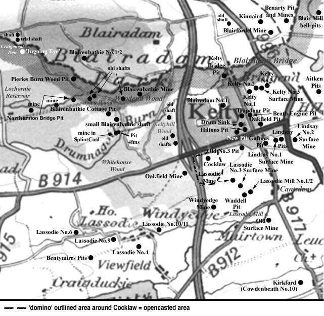 |
 |
After 1856, into the later decades of the nineteenth century, the number of pits in and around Kelty mushroomed at an amazing rate.
 |
Blairadam Colliery (19th century report)
| Coal seams worked | Thickness | Quality | Class |
|---|---|---|---|
| Main Coal | 6 ft. 6 in. | Good | Steam |
| Kinglassie Splint | 4 ft. 4 in. | Fair | Splint |
| Coal (not identified) | 3 ft. 8 in. | Fair | Splint |
| Coal (not identified) | 3 ft. 6 in. | Good | Splint |
-----------------------------------------------
Statistical Account - Parish of Cleish - 1791
... There is also coal in the estate of Blair, belonging to John Adam, Esq., of Maryburgh. It has produced £180 a year; but it has not been wrought for some time, on account of its vicinity to the proprietor's house. ...
The fuel used in the parish is coal and peat, with both of which the inhabitants are well supplied. Coal is got in two places, about a mile distant from the east and south east parts of the parish. The price, on the spot, is 6d. for 18 stone of great coal, and 4d. the small coal or chews. These coals are of excellent quality. ...
-----------------------------------------------
Statistical Account - Parish of Cleish - 1839
...There is coal on the estate of Blair-Adam, which was formerly wrought to a considerable extent; it is a branch of the Kelty coal. As it is near the proprietor's house, it has not been wrought for many years. There is also coal in the hill, but the seams are thin, and nearly perpendicular, so as not to be worth working. ...
-----------------------------------------------
Information on coals worked at, or near, Blairadam Bridge Pits
(based on a report from 1934)
The Bank Coal came to the surface in the area between
Kelty Bridge and Blairadam Bridge. Numerous sits* on the
banks of the Kelty Burn some 400 yds, west from Blairadam
Bridge marked old workings at its outcrop. The Bank Coal
outcrop was overlain by a thick, coarse sandstone which
formed the high ground on both sides of the Burn.
The outcrop ran north-eastwards through the Den to the Ochil
fault. The Bank Coal or Lochgelly Parrot Coal in the area was
normally a composite seam supplying a fair household coal.
Reserves in the Bank Coal were considered to be large, lying
mainly in the Kelty coalfield between Moraybank and
Blairfordel.
* A sit is a subsidence of the surface caused by a removal of
coal below.
| Please see the GLOSSARY in the COAL SEAMS section of the website for descriptions of other mining terms. |
|---|
The Blairadam Coalfield
(based on a 1900 report)
The Blairadam basin, with its lower Dunfermline coals, had a breadth of more than a mile on the Blairadam estate, Kelty. The position of its coals were fixed by reference to Hosie Limestones which were found exactly as at the Dunfermline coalfield. Two of the limestones cropped out in the Lochornie Burn and the same seams were proved in a series of bores as far south as the Blairadam Brick and Tile Works. The position of these limestones marked the southern and south-eastern limits of the basin which, besides dislocations, had several whinstone intrusions. A thin, persistent sill extended for over a mile, a little to the east of the crop of the Rough Coal, and dipped eastward, like the strata among which it lay. It cropped out at the surface in quarries to the west and north-west of Shiells and it appeared to be brought up again by the effect of another fault at Shiells Farm. It was met with in several bores in the neighbourhood and by the help of sections in the local burns, and evidence from these bores, it was possible to trace the outcrops of some coal seams. The Dunfermline Splint outcrop was not detected beyond the mosses that lay to the east of Loch Glow, but from there it probably ranged southward across the Lochornie Burn, a little to the east of the limestones. It circled round the southern end of the great sill, and bending north-eastward, made for the Glen Burn, south of Blairadam House, where some of the coals have been worked in former times by openings along the outcrop. Traces of these shallow pits could be seen in this Glen on both sides of the sill. On the west side, a seam supposed to have been the Eight Foot Coal was mined, where the strata had a dip of 15° to the east. On the east side, the dip was north-westerly under the sill at Kiery Craigs, and it was again evident that several seams cropped out and were once mined. Two seams in particular have been worked rather extensively to the north-east of Blairadam House; the lower of these being 4 ft. thick and the upper 10 ft. They dipped towards the north-west, the same direction as the workings. Immediately east of the Blairadam basin, the coal seams folded over an anticlinal arch, and dipped towards the east to form the Kelty coalfield.
